IMAGES TAKEN NEAR TO
ANNAN, DG12 5RP
Introduction
This page details the photographs taken nearby to DG12 5RP by members of the Geograph project.
The Geograph project started in 2005 with the aim of publishing, organising and preserving representative images for every square kilometre of Great Britain, Ireland and the Isle of Man.

There are currently over 7.5m images from over14,400 individuals and you can help contribute to the project by visiting https://www.geograph.org.uk
Image Map
Images are licensed for reuse under creativecommons.org/licenses/by-sa/2.0
Notes
- Clicking on the map will re-center to the selected point.
- The higher the marker number, the further away the image location is from the centre of the postcode.
Image Listing (6 Images Found)
Images are licensed for reuse under creativecommons.org/licenses/by-sa/2.0
Image
Details
Distance
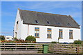
2
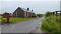
A conversion
This was clearly some sort of public building, bearing the Royal Cipher GVIR 1939. Now in the process of being converted to a private dwelling house - but what was its previous role?
Image: © Oliver Dixon
Taken: 28 Sep 2007
0.15 miles
3
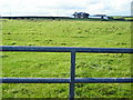
Breckhead
A cottage named on OS mapping beside the minor road to Ecclefechan.
Image: © Jonathan Billinger
Taken: 15 Aug 2013
0.17 miles
4
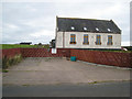
Former Bowhill Exchange
Now converted for residential use
Image: © Leslie Barrie
Taken: 7 Aug 2014
0.17 miles
5
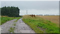
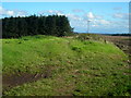
Muddy track to Wintersheugh
The unnamed plantation to the left is coniferous.
Image: © Jonathan Billinger
Taken: 15 Aug 2013
0.20 miles