IMAGES TAKEN NEAR TO
ANNAN, DG12 5RF
Introduction
This page details the photographs taken nearby to DG12 5RF by members of the Geograph project.
The Geograph project started in 2005 with the aim of publishing, organising and preserving representative images for every square kilometre of Great Britain, Ireland and the Isle of Man.

There are currently over 7.5m images from over14,400 individuals and you can help contribute to the project by visiting https://www.geograph.org.uk
Image Map (Loading...)


Getting Data...Please wait
Leaflet Map data © OpenStreetMap
Images are licensed for reuse under creativecommons.org/licenses/by-sa/2.0
Notes
- Clicking on the map will re-center to the selected point.
- The higher the marker number, the further away the image location is from the centre of the postcode.
Image Listing (4 Images Found)
Images are licensed for reuse under creativecommons.org/licenses/by-sa/2.0
Image
Details
Distance
1

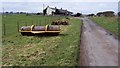
Agricultural bric-a-brac
Assorted farming equipment and bales.
Image: © Oliver Dixon
Taken: 28 Sep 2007
0.02 miles
2
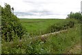
Millside Bridge
Crossing the Millside Burn by farm buildings.
Image: © Richard Webb
Taken: 27 Jul 2016
0.05 miles
3
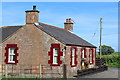
Cottages at the entrance to Limekilns.
Agricultural machine park as well.
Image: © John Holmes
Taken: 25 Mar 2006
0.15 miles