IMAGES TAKEN NEAR TO
Powfoot, ANNAN, DG12 5QE
Introduction
This page details the photographs taken nearby to DG12 5QE by members of the Geograph project.
The Geograph project started in 2005 with the aim of publishing, organising and preserving representative images for every square kilometre of Great Britain, Ireland and the Isle of Man.

There are currently over 7.5m images from over14,400 individuals and you can help contribute to the project by visiting https://www.geograph.org.uk
Image Map (Loading...)


Getting Data...Please wait
Leaflet Map data © OpenStreetMap
Images are licensed for reuse under creativecommons.org/licenses/by-sa/2.0
Notes
- Clicking on the map will re-center to the selected point.
- The higher the marker number, the further away the image location is from the centre of the postcode.
Image Listing (7 Images Found)
Images are licensed for reuse under creativecommons.org/licenses/by-sa/2.0
Image
Details
Distance
1
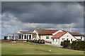
Club House, Powfoot Golf Club
Founded 1903
Image: © Leslie Barrie
Taken: 7 Aug 2014
0.02 miles
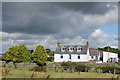
3
Flowering bushes at edge of golf course in May
Image: © Thomas Dick
Taken: 19 May 2008
0.16 miles
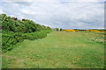
5
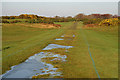
A track running across Powfoot Golf Course
Viewed from the coastal road at Powfoot on a fine November morning.
Image: © Walter Baxter
Taken: 29 Nov 2008
0.24 miles
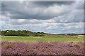
6
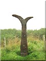
National Cycle Network 7 milepost
This is one of a series of mileposts that were erected on the National Cycle Network 7 as a Millennium project. This one shows that it is 20 miles west to Dumfries and 4 miles east to Annan.
Image: © Ann Cook
Taken: 12 Sep 2009
0.24 miles
7
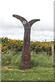
Millennium Milepost
One of the specially designed millennium mileposts, this one by the car park at Powfoot Scar.
Image: © Anne Burgess
Taken: 20 May 2009
0.25 miles