IMAGES TAKEN NEAR TO
Cummertrees, ANNAN, DG12 5PU
Introduction
This page details the photographs taken nearby to DG12 5PU by members of the Geograph project.
The Geograph project started in 2005 with the aim of publishing, organising and preserving representative images for every square kilometre of Great Britain, Ireland and the Isle of Man.

There are currently over 7.5m images from over14,400 individuals and you can help contribute to the project by visiting https://www.geograph.org.uk
Image Map
Images are licensed for reuse under creativecommons.org/licenses/by-sa/2.0
Notes
- Clicking on the map will re-center to the selected point.
- The higher the marker number, the further away the image location is from the centre of the postcode.
Image Listing (6 Images Found)
Images are licensed for reuse under creativecommons.org/licenses/by-sa/2.0
Image
Details
Distance
1
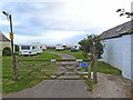
National Cycle Network at Queensberry Bay Holiday Park
National Cycle Network route 7 here passes along private roads through the Queensberry Bay Holiday Park at Riddindyke.
Image: © Oliver Dixon
Taken: 2 Sep 2013
0.03 miles
2
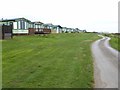
National Cycle Network at Queensberry Bay Holiday Park
National Cycle Network route 7 here passes along private roads through the Queensberry Bay Holiday Park at Riddindyke. Static caravans line the route to the left. To the right are extensive open views over the Solway Firth.
Image: © Oliver Dixon
Taken: 2 Sep 2013
0.16 miles
3
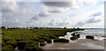
Caravan site at Riddindyke viewed from shore.
Image: © Barry Dale
Taken: 15 Aug 2007
0.16 miles
4
Powfoot
Powfoot
Check it out on my Flickr page.
https://www.flickr.com/photos/jetjohn/31954843424/
Powfoot beach is a small strip of sand and shingle beach along the coast towards Annan.
It is a shore where the Solway Firth meets the hamlet of Powfoot. The beach is suitable for paddling but not for swimming. There is a local coastal footpath and plenty of birdlife around the area to watch.
Image: © James Johnstone
Taken: 28 Mar 2016
0.21 miles
5
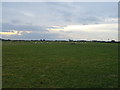
Grazing, Riddindyke
Flat coastal land towards the Solway Firth.
Image: © JThomas
Taken: 20 Nov 2019
0.21 miles
6
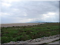
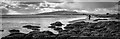
Powfoot Beach
A cloudy day at Powfoot - the low tide revealing the fine sandy beach beyond the grass banks by Riddindyke. In the distance is Criffal (569m).
Image: © Chris Newman
Taken: 16 May 2008
0.24 miles