IMAGES TAKEN NEAR TO
Brydekirk, ANNAN, DG12 5LP
Introduction
This page details the photographs taken nearby to DG12 5LP by members of the Geograph project.
The Geograph project started in 2005 with the aim of publishing, organising and preserving representative images for every square kilometre of Great Britain, Ireland and the Isle of Man.

There are currently over 7.5m images from over14,400 individuals and you can help contribute to the project by visiting https://www.geograph.org.uk
Image Map (Loading...)


Getting Data...Please wait
Leaflet Map data © OpenStreetMap
Images are licensed for reuse under creativecommons.org/licenses/by-sa/2.0
Notes
- Clicking on the map will re-center to the selected point.
- The higher the marker number, the further away the image location is from the centre of the postcode.
Image Listing (11 Images Found)
Images are licensed for reuse under creativecommons.org/licenses/by-sa/2.0
Image
Details
Distance
4
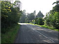
Minor road towards Brydekirk
Heading south west.
Image: © JThomas
Taken: 3 Oct 2015
0.01 miles
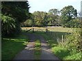
5
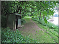
Fishermen's shelter
The path pictured follows the bank of the River Annan near Brydekirk. The river is popular wtrh anglers, and at least two of these simple shelters exist for their benefit. I thought at first that they were hides for birdwatchers, but there is a notice inside one of the shelters asking anglers to submit a record of their catch.
Image: © Richard Dorrell
Taken: 14 Jun 2013
0.11 miles
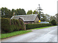
6
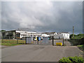
Kingan Farm Feeds, Brydekirk
Owned by BOCM PAULS since 2004, but retaining the name of James Kingan & Sons, the works produces a range of blended foods for farm animals.
Image: © Richard Dorrell
Taken: 14 Jun 2013
0.11 miles
7
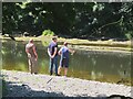
Fishing near Brydekirk
Anglers on the River Annan upstream of the bridge.
Image: © Jim Barton
Taken: 15 Jul 2021
0.11 miles
8
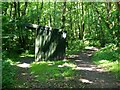
Fishing shelter near Brydekirk
An open hut by the Annandale Way north of Brydekirk.
Image: © Jim Barton
Taken: 15 Jul 2021
0.13 miles
9
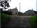
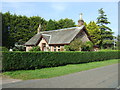
Approach to Brydekirk Mains
Part of the farm steading is the gable wall of a C17 laird’s house, likely to be remains of Brydekirk Tower. Nearby are the remains of St Bryde’s medieval church.
Image: © Chris Newman
Taken: 17 Sep 2008
0.19 miles
10
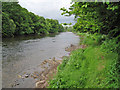
River Annan, Brydekirk
Looking upstream. The river is popular with fishermen.
Image: © Richard Dorrell
Taken: 14 Jun 2013
0.24 miles