IMAGES TAKEN NEAR TO
ANNAN, DG12 5LN
Introduction
This page details the photographs taken nearby to DG12 5LN by members of the Geograph project.
The Geograph project started in 2005 with the aim of publishing, organising and preserving representative images for every square kilometre of Great Britain, Ireland and the Isle of Man.

There are currently over 7.5m images from over14,400 individuals and you can help contribute to the project by visiting https://www.geograph.org.uk
Image Map
Images are licensed for reuse under creativecommons.org/licenses/by-sa/2.0
Notes
- Clicking on the map will re-center to the selected point.
- The higher the marker number, the further away the image location is from the centre of the postcode.
Image Listing (9 Images Found)
Images are licensed for reuse under creativecommons.org/licenses/by-sa/2.0
Image
Details
Distance
1
Landheads water works
Annan's water supply.
Image: © Richard Webb
Taken: 5 Mar 2017
0.06 miles
2
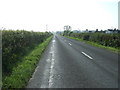
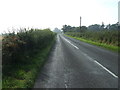
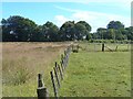
Yellow road near Annan
Running past the waterworks and Mount Annan. The woods in the distance are on the site of a quarry.
Image: © Richard Webb
Taken: 5 Mar 2017
0.07 miles
3
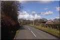
Heading south west towards Annan
On the B722.
Image: © JThomas
Taken: 3 Oct 2015
0.08 miles
5
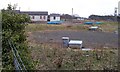
A Scottish Water site.
The blue seems so out of place above ground.
Image: © John Holmes
Taken: 25 Mar 2006
0.11 miles
6
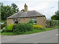
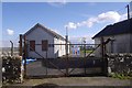
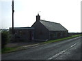
Former tollhouse
Surveyed by the Milestone Society. The tollbar cottage at Landheads on the B722 Annan to Kirtlebridge road at the junction of a minor road that goes to Ecclefechan. This would have served travellers on the Annan to Langholm Trust road of 1777.
Image: © Alverie Weighill
Taken: 11 Jul 2012
0.12 miles
8
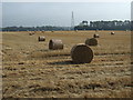
Stubble field with bales near Redhouse
Off the B722.
Image: © JThomas
Taken: 3 Oct 2015
0.12 miles