IMAGES TAKEN NEAR TO
Standalane, ANNAN, DG12 5JW
Introduction
This page details the photographs taken nearby to Standalane, DG12 5JW by members of the Geograph project.
The Geograph project started in 2005 with the aim of publishing, organising and preserving representative images for every square kilometre of Great Britain, Ireland and the Isle of Man.

There are currently over 7.5m images from over14,400 individuals and you can help contribute to the project by visiting https://www.geograph.org.uk
Image Map (Loading...)


Getting Data...Please wait
Leaflet Map data © OpenStreetMap
Images are licensed for reuse under creativecommons.org/licenses/by-sa/2.0
Notes
- Clicking on the map will re-center to the selected point.
- The higher the marker number, the further away the image location is from the centre of the postcode.
Image Listing (4 Images Found)
Images are licensed for reuse under creativecommons.org/licenses/by-sa/2.0
Image
Details
Distance
1
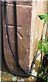
Benchmark on No. 6 Edward Place
Ordnance Survey cut mark benchmark described on the Bench Mark Database at www.bench-marks.org.uk/bm134442
Image: © Luke Shaw
Taken: 4 Nov 2020
0.18 miles
2
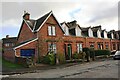
Edward Place houses
There is an Ordnance Survey benchmark Image on the front left hand corner of the nearest house ate the junction with its attached garage
Image: © Luke Shaw
Taken: 4 Nov 2020
0.19 miles
3
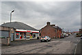
Convenience store, Butts Street, Annan
Standing at the corner of Mill Park Crescent.
Image: © Richard Dorrell
Taken: 15 Dec 2016
0.23 miles
4
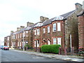
Charles Street
A street of substantial red sandstone houses in central Annan.
Image: © Colin Smith
Taken: 15 Aug 2009
0.25 miles