IMAGES TAKEN NEAR TO
Northfield Park, ANNAN, DG12 5EZ
Introduction
This page details the photographs taken nearby to Northfield Park, DG12 5EZ by members of the Geograph project.
The Geograph project started in 2005 with the aim of publishing, organising and preserving representative images for every square kilometre of Great Britain, Ireland and the Isle of Man.

There are currently over 7.5m images from over14,400 individuals and you can help contribute to the project by visiting https://www.geograph.org.uk
Image Map
Images are licensed for reuse under creativecommons.org/licenses/by-sa/2.0
Notes
- Clicking on the map will re-center to the selected point.
- The higher the marker number, the further away the image location is from the centre of the postcode.
Image Listing (5 Images Found)
Images are licensed for reuse under creativecommons.org/licenses/by-sa/2.0
Image
Details
Distance
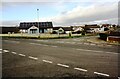
3
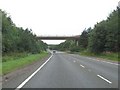
Bridge over the A75
The B722 Annan to Eaglesfield road crosses the A75 Stranraer Road (Annan by-pass) without any change of elevation. The Northfield Park estate is to the right of the road
Image: © Oliver Dixon
Taken: 31 Jul 2013
0.18 miles
4
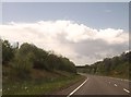
Crossing the River Annan
B722 overbridge ahead
Image: © John Firth
Taken: 19 May 2013
0.21 miles
5
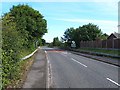
Housing at junction of Tweedie Terrace and Kennels Road
Ordnance Survey documents indicate that a benchmark levelled at 26.491m above Newlyn Datum was verified in 1974 on a gatepost at a field entrance at this location
Image: © Luke Shaw
Taken: 4 Nov 2020
0.23 miles