IMAGES TAKEN NEAR TO
Silverlaw, ANNAN, DG12 5EQ
Introduction
This page details the photographs taken nearby to Silverlaw, DG12 5EQ by members of the Geograph project.
The Geograph project started in 2005 with the aim of publishing, organising and preserving representative images for every square kilometre of Great Britain, Ireland and the Isle of Man.

There are currently over 7.5m images from over14,400 individuals and you can help contribute to the project by visiting https://www.geograph.org.uk
Image Map (Loading...)


Getting Data...Please wait
Leaflet Map data © OpenStreetMap
Images are licensed for reuse under creativecommons.org/licenses/by-sa/2.0
Notes
- Clicking on the map will re-center to the selected point.
- The higher the marker number, the further away the image location is from the centre of the postcode.
Image Listing (10 Images Found)
Images are licensed for reuse under creativecommons.org/licenses/by-sa/2.0
Image
Details
Distance
1
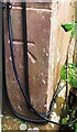
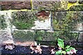
Benchmark on No. 6 Edward Place
Ordnance Survey cut mark benchmark described on the Bench Mark Database at www.bench-marks.org.uk/bm134442
Image: © Luke Shaw
Taken: 4 Nov 2020
0.15 miles
2
Housing at junction of Tweedie Terrace and Kennels Road
Ordnance Survey documents indicate that a benchmark levelled at 26.491m above Newlyn Datum was verified in 1974 on a gatepost at a field entrance at this location
Image: © Luke Shaw
Taken: 4 Nov 2020
0.16 miles
3
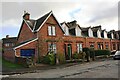
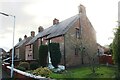
Edward Place houses
There is an Ordnance Survey benchmark Image on the front left hand corner of the nearest house ate the junction with its attached garage
Image: © Luke Shaw
Taken: 4 Nov 2020
0.16 miles
4
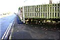
Angled wall on south side of Tweedie Terrace at North Street junction
There is an Ordnance Survey benchmark Image on the stone in the wall with a white triangular patch under the 10th slat from the left hand end of the fence
Image: © Luke Shaw
Taken: 4 Nov 2020
0.21 miles
5
Houses on Addison Place (No. 14 nearest)
Ordnance Survey records indicate that a benchmark levelled at 19.288m above Newlyn Datum was verified in 1974 on the side of the nearest house at its front corner
Image: © Luke Shaw
Taken: 4 Nov 2020
0.21 miles
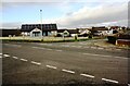
6
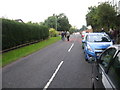
North Street in Annan
Looking towards the town centre from outside of Annan's football ground.
Image: © James Denham
Taken: 21 Sep 2013
0.22 miles
7
Benchmark on angled wall at North Street / Tweedie Terrace junction
Ordnance Survey cut mark benchmark described on the Bench Mark Database at www.bench-marks.org.uk/bm134440
Image: © Luke Shaw
Taken: 4 Nov 2020
0.22 miles
8
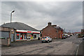
Convenience store, Butts Street, Annan
Standing at the corner of Mill Park Crescent.
Image: © Richard Dorrell
Taken: 15 Dec 2016
0.23 miles
9
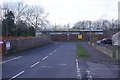
Silverlaw
Residential road in Annan with Annan Athletic's Gala Bank ground at the end.
Image: © Richard Webb
Taken: 5 Mar 2017
0.23 miles
10
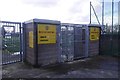
Turnstile, Gala Bank
Annan Athletic's tidy ground.
Image: © Richard Webb
Taken: 5 Mar 2017
0.24 miles