IMAGES TAKEN NEAR TO
Main Road, DUMFRIES, DG1 1WD
Introduction
This page details the photographs taken nearby to Main Road, DG1 1WD by members of the Geograph project.
The Geograph project started in 2005 with the aim of publishing, organising and preserving representative images for every square kilometre of Great Britain, Ireland and the Isle of Man.

There are currently over 7.5m images from over14,400 individuals and you can help contribute to the project by visiting https://www.geograph.org.uk
Image Map
Images are licensed for reuse under creativecommons.org/licenses/by-sa/2.0
Notes
- Clicking on the map will re-center to the selected point.
- The higher the marker number, the further away the image location is from the centre of the postcode.
Image Listing (9 Images Found)
Images are licensed for reuse under creativecommons.org/licenses/by-sa/2.0
Image
Details
Distance
2
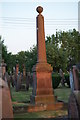
Monument in Kirkmahoe Churchyard
An impressive pillar monument
Image: © Alice Howdle
Taken: 26 Jun 2010
0.03 miles
5
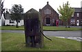
Kirkton water pump
The old village water pump at Kirkton.
Image: © Colin Kinnear
Taken: 26 Jun 2008
0.06 miles
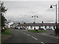
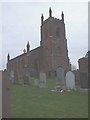
6
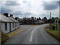
Kirkton
A view south through this picturesque village situated a short distance north of Dumfries. The village has many fine buildings clustered around a triangular village green which can be seen in the photograph.
Image: © Kevin Rae
Taken: 28 Jul 2006
0.08 miles
7
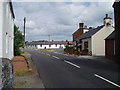
Kirkton
A view north along the main street of this picturesque village showing the triangular village green at its centre.
Image: © Kevin Rae
Taken: 28 Jul 2006
0.08 miles
8
Disused mill race
The mill race runs beside the burn and is now used as a footpath.
Image: © Alice Howdle
Taken: 26 Jun 2010
0.19 miles
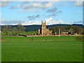
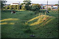
9
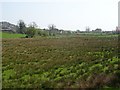
Kirkton
A rashy field north of the village.
Image: © Richard Webb
Taken: 22 Apr 2019
0.21 miles