IMAGES TAKEN NEAR TO
Duncow, DUMFRIES, DG1 1TA
Introduction
This page details the photographs taken nearby to DG1 1TA by members of the Geograph project.
The Geograph project started in 2005 with the aim of publishing, organising and preserving representative images for every square kilometre of Great Britain, Ireland and the Isle of Man.

There are currently over 7.5m images from over14,400 individuals and you can help contribute to the project by visiting https://www.geograph.org.uk
Image Map
Images are licensed for reuse under creativecommons.org/licenses/by-sa/2.0
Notes
- Clicking on the map will re-center to the selected point.
- The higher the marker number, the further away the image location is from the centre of the postcode.
Image Listing (9 Images Found)
Images are licensed for reuse under creativecommons.org/licenses/by-sa/2.0
Image
Details
Distance
4
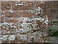
Duncow School
Benchmark on Duncow School.
Image: © Rab McMurdo
Taken: 12 Feb 2023
0.18 miles
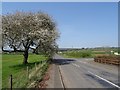
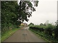
6
A road junction near Duncow Bridge
Duncow school is on the left.
Image: © Ann Cook
Taken: 17 Sep 2013
0.18 miles
7
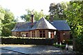
North Lodge
Unused access to Duncow House.
Image: © Russel Wills
Taken: 29 Sep 2021
0.22 miles
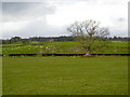
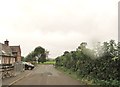
8
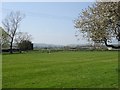
Playing field, Duncow
Opposite the school.
Image: © Richard Webb
Taken: 22 Apr 2019
0.22 miles