IMAGES TAKEN NEAR TO
Locharbriggs, DUMFRIES, DG1 1QE
Introduction
This page details the photographs taken nearby to DG1 1QE by members of the Geograph project.
The Geograph project started in 2005 with the aim of publishing, organising and preserving representative images for every square kilometre of Great Britain, Ireland and the Isle of Man.

There are currently over 7.5m images from over14,400 individuals and you can help contribute to the project by visiting https://www.geograph.org.uk
Image Map
Images are licensed for reuse under creativecommons.org/licenses/by-sa/2.0
Notes
- Clicking on the map will re-center to the selected point.
- The higher the marker number, the further away the image location is from the centre of the postcode.
Image Listing (7 Images Found)
Images are licensed for reuse under creativecommons.org/licenses/by-sa/2.0
Image
Details
Distance
1
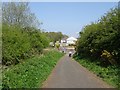
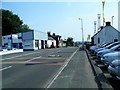
Dumfries, Lochmaben and Lockerbie Railway trackbed
The trackbed cycle path ends here on Quarry Road.
Image: © Richard Webb
Taken: 22 Apr 2019
0.09 miles
3
Entering Locharbriggs from the south: site of former station, 2000
View northward from footbridge over the A701. The station, which had been on the left, had been on the ex-Caledonian Railway Lockerbie - Dumfries line, being closed 19/5/52 to passengers when services ceased on the line, goods 4/5/64: the line was closed entirely from 18/4/66.
Image: © Ben Brooksbank
Taken: 23 Jun 2000
0.11 miles
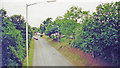
4
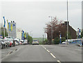
A701 north through Locharbriggs
Motor dealerships on the left are GK and Arnold Clark
Image: © John Firth
Taken: 10 May 2012
0.15 miles
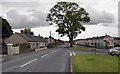
6
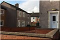
Locharbriggs
Mixed residential and industrial area on the northern outskirts of Dumfries.
Image: © Lynne Kirton
Taken: 25 Jul 2006
0.20 miles