IMAGES TAKEN NEAR TO
Ecclefechan, LOCKERBIE, DG11 3JA
Introduction
This page details the photographs taken nearby to DG11 3JA by members of the Geograph project.
The Geograph project started in 2005 with the aim of publishing, organising and preserving representative images for every square kilometre of Great Britain, Ireland and the Isle of Man.

There are currently over 7.5m images from over14,400 individuals and you can help contribute to the project by visiting https://www.geograph.org.uk
Image Map (Loading...)


Getting Data...Please wait
Leaflet Map data © OpenStreetMap
Images are licensed for reuse under creativecommons.org/licenses/by-sa/2.0
Notes
- Clicking on the map will re-center to the selected point.
- The higher the marker number, the further away the image location is from the centre of the postcode.
Image Listing (6 Images Found)
Images are licensed for reuse under creativecommons.org/licenses/by-sa/2.0
Image
Details
Distance
1
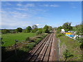
Ecclefechan railway station (site), Dumfries & Galloway
Opened in 1847 by the Caledonian Railway on the line from Carlisle to Glasgow, this station closed in 1960 and was demolished.
View west towards Lockerbie and Glasgow. No trace apparently remains.
Image: © Nigel Thompson
Taken: 10 May 2019
0.14 miles
4
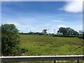
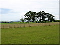
Johnstonebank Farm
Viewed across the field from the A74(M)
Image: © Eirian Evans
Taken: 9 Jul 2022
0.18 miles
5
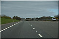
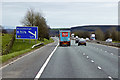
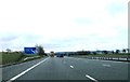
Dumfries and Galloway : The A74(M) Motorway
Heading north through Dumfries and Galloway.
Image: © Lewis Clarke
Taken: 22 Apr 2016
0.20 miles