IMAGES TAKEN NEAR TO
Waterbeck, LOCKERBIE, DG11 3EZ
Introduction
This page details the photographs taken nearby to DG11 3EZ by members of the Geograph project.
The Geograph project started in 2005 with the aim of publishing, organising and preserving representative images for every square kilometre of Great Britain, Ireland and the Isle of Man.

There are currently over 7.5m images from over14,400 individuals and you can help contribute to the project by visiting https://www.geograph.org.uk
Image Map
Images are licensed for reuse under creativecommons.org/licenses/by-sa/2.0
Notes
- Clicking on the map will re-center to the selected point.
- The higher the marker number, the further away the image location is from the centre of the postcode.
Image Listing (17 Images Found)
Images are licensed for reuse under creativecommons.org/licenses/by-sa/2.0
Image
Details
Distance
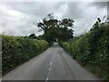
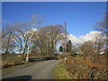
1
The road to Waterbeck at Gowkhall Bridge
Image: © Jonathan Thacker
Taken: 24 Nov 2018
0.03 miles
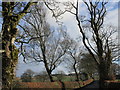
4
Kirtle Water path
Taken from the bridge a wide path follows the Kirtle Water.
Image: © Colin Kinnear
Taken: 6 Feb 2018
0.08 miles
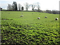
5
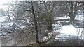
Between the Waters
An appropriately named farm, as it is between Kirk Burn and Kirtle Water. I'm not sure what species the dead trees were.
Image: © M J Richardson
Taken: 2 Oct 2021
0.10 miles
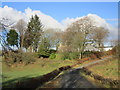
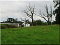
6
Between the Waters
A farm close to Waterbeck.
Image: © Jonathan Thacker
Taken: 24 Nov 2018
0.10 miles
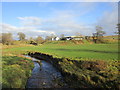
8
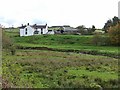
"Between the Waters" Farm, Waterbeck
The farm lies in the angle made by the confluence of the Kirk Burn (in picture) with the Kirtle Water (off picture to the right).
Image: © Oliver Dixon
Taken: 19 Oct 2010
0.11 miles
9
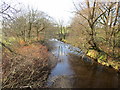
Kirtle Water below Gowkhall Bridge
Image: © Jonathan Thacker
Taken: 24 Nov 2018
0.13 miles