IMAGES TAKEN NEAR TO
Castle-Break, LOCKERBIE, DG11 3DX
Introduction
This page details the photographs taken nearby to Castle-Break, DG11 3DX by members of the Geograph project.
The Geograph project started in 2005 with the aim of publishing, organising and preserving representative images for every square kilometre of Great Britain, Ireland and the Isle of Man.

There are currently over 7.5m images from over14,400 individuals and you can help contribute to the project by visiting https://www.geograph.org.uk
Image Map
Images are licensed for reuse under creativecommons.org/licenses/by-sa/2.0
Notes
- Clicking on the map will re-center to the selected point.
- The higher the marker number, the further away the image location is from the centre of the postcode.
Image Listing (40 Images Found)
Images are licensed for reuse under creativecommons.org/licenses/by-sa/2.0
Image
Details
Distance
1
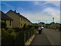
Walking the dog
Walking the dog near Trotters Towers Ecclefechan
Image: © danny kearney
Taken: 7 Aug 2013
0.02 miles
4
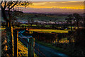
"Sleepy Valley" Downtown Ecclefechan
Ecclefechan taken from the top of "The Clint" and looking across The Solway Firth towards the radio masts at Anthorn.
Image: © James Johnstone
Taken: 11 Jan 2014
0.10 miles
5
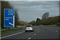
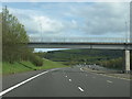
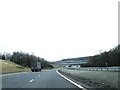
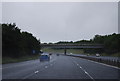
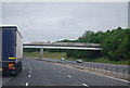
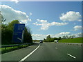
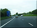
Dumfries and Galloway : The A74(M) Motorway
Heading north along the A74(M) near Ecclefechan.
Image: © Lewis Clarke
Taken: 22 Apr 2016
0.10 miles