IMAGES TAKEN NEAR TO
Kirkpatrick Fleming, LOCKERBIE, DG11 3BG
Introduction
This page details the photographs taken nearby to DG11 3BG by members of the Geograph project.
The Geograph project started in 2005 with the aim of publishing, organising and preserving representative images for every square kilometre of Great Britain, Ireland and the Isle of Man.

There are currently over 7.5m images from over14,400 individuals and you can help contribute to the project by visiting https://www.geograph.org.uk
Image Map
Images are licensed for reuse under creativecommons.org/licenses/by-sa/2.0
Notes
- Clicking on the map will re-center to the selected point.
- The higher the marker number, the further away the image location is from the centre of the postcode.
Image Listing (7 Images Found)
Images are licensed for reuse under creativecommons.org/licenses/by-sa/2.0
Image
Details
Distance
1
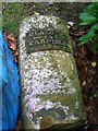
Old Milestone by Mossknowe House, Kirkpatrick Fleming parish
Formerly by the B7076 (old A74), in parish of Kirkpatrick Fleming (Annandale District), Kirkpatrick Fleming, Mossknowe House, laid on ground at left front of house. Originally located at approximately: Image, Northeast side of road.
Inscription reads:-
GLASG(OW)
{<-arrow} 82
CARLISLE
12½ {arrow->}
Surveyed
Milestone Society National ID: DG_CLGW12
Image: © Milestone Society
Taken: Unknown
0.05 miles
2

Farm bridge over the Kirtle Water
Leading to Mossknowe.
Image: © Oliver Dixon
Taken: 19 Oct 2010
0.15 miles
3
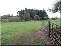
Field path and footbridge crossing Kirtle Water
Looking eastward. This gives access to Mossknowe.
Image: © Peter Wood
Taken: 28 Sep 2024
0.17 miles


7

Bridge over the Kirtle Water
Carrying the B6357 from Annan to Kirkpatrick Fleming.
Image: © Oliver Dixon
Taken: 19 Oct 2010
0.25 miles