
IMAGES TAKEN NEAR TO
Kirtlebridge, LOCKERBIE, DG11 3AR
Introduction
This page details the photographs taken nearby to DG11 3AR by members of the Geograph project.
The Geograph project started in 2005 with the aim of publishing, organising and preserving representative images for every square kilometre of Great Britain, Ireland and the Isle of Man.

There are currently over 7.5m images from over14,400 individuals and you can help contribute to the project by visiting https://www.geograph.org.uk
Image Map
Images are licensed for reuse under creativecommons.org/licenses/by-sa/2.0
Notes
- Clicking on the map will re-center to the selected point.
- The higher the marker number, the further away the image location is from the centre of the postcode.
Image Listing (3 Images Found)
Images are licensed for reuse under creativecommons.org/licenses/by-sa/2.0
Image
Details
Distance
1
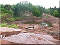
Cove Quarry
This quarry exploits the Rottington Sandstone Member of the St Bees Sandstone Formation, which is of Triassic age, and belongs to the New Red Sandstone. It has been used all over Britain, for example in Ashby Castle at Ashby-de-la-Zouch and Stag Place Piazza in London as well as in Edinburgh and Glasgow. Large quantities of the stone were shipped to North America as ballast and used in various buildings on the eastern seaboard, including the base of the Statue of Liberty in New York. The red colour implies that it was laid down in a desert environment. The lower part of the quarry is dominated by sheet sandstones interbedded with red mudstones with desiccation cracks, probably deposited as a terminal fan system on a semi-arid ephemeral playa-mudflat. It grades upwards into thicker beds and the mudstone proportion decreases. Eventually it evolved into a large braided fluvial system, and it is recognised across the Irish Sea basin.
Image: © Anne Burgess
Taken: 23 May 2009
0.20 miles
3
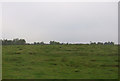
Hillside grazing near Woodhouse Cottage Wood
Image: © JThomas
Taken: 3 Oct 2015
0.24 miles