IMAGES TAKEN NEAR TO
Eaglesfield, LOCKERBIE, DG11 3AF
Introduction
This page details the photographs taken nearby to DG11 3AF by members of the Geograph project.
The Geograph project started in 2005 with the aim of publishing, organising and preserving representative images for every square kilometre of Great Britain, Ireland and the Isle of Man.

There are currently over 7.5m images from over14,400 individuals and you can help contribute to the project by visiting https://www.geograph.org.uk
Image Map (Loading...)


Getting Data...Please wait
Leaflet Map data © OpenStreetMap
Images are licensed for reuse under creativecommons.org/licenses/by-sa/2.0
Notes
- Clicking on the map will re-center to the selected point.
- The higher the marker number, the further away the image location is from the centre of the postcode.
Image Listing (6 Images Found)
Images are licensed for reuse under creativecommons.org/licenses/by-sa/2.0
Image
Details
Distance
1
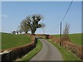
Lane, Logan Bridge
A minor road descends to Logan Bridge.
Image: © Richard Webb
Taken: 31 Mar 2007
0.21 miles
2
Flowdens Flow
The name suggests this was once a peat bog. Now a conifer plantation.
Image: © Richard Webb
Taken: 31 Mar 2007
0.21 miles
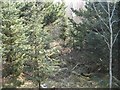
3
Flowdens Flow
Forest road in the young plantation.
Image: © Richard Webb
Taken: 31 Mar 2007
0.23 miles
4
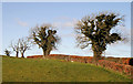
Trees at Logan Bridge
These ivy-clad trees are by a minor road near Flowdens.
Image: © Walter Baxter
Taken: 23 Nov 2010
0.23 miles
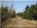
5
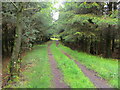
Track through Flowdens Flow
Looking north-westward.
Image: © Peter Wood
Taken: 16 May 2022
0.24 miles
6
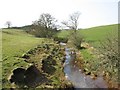
Logan Burn
View upstream from Logan Bridge.
Image: © Richard Webb
Taken: 31 Mar 2007
0.24 miles