IMAGES TAKEN NEAR TO
LOCKERBIE, DG11 2QF
Introduction
This page details the photographs taken nearby to DG11 2QF by members of the Geograph project.
The Geograph project started in 2005 with the aim of publishing, organising and preserving representative images for every square kilometre of Great Britain, Ireland and the Isle of Man.

There are currently over 7.5m images from over14,400 individuals and you can help contribute to the project by visiting https://www.geograph.org.uk
Image Map
Images are licensed for reuse under creativecommons.org/licenses/by-sa/2.0
Notes
- Clicking on the map will re-center to the selected point.
- The higher the marker number, the further away the image location is from the centre of the postcode.
Image Listing (9 Images Found)
Images are licensed for reuse under creativecommons.org/licenses/by-sa/2.0
Image
Details
Distance
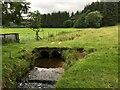
2
The B7068 at Paddockhole Bridge
The bridge carries an unclassified road over the Water of Milk.
Image: © M J Richardson
Taken: 2 Oct 2021
0.08 miles
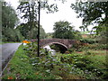
3

Paddockhill Bridge
Over the Water of Milk.
Image: © Richard Webb
Taken: 8 Oct 2015
0.09 miles
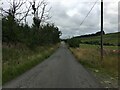
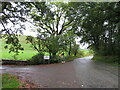
4
B7068, Paddockhole
Langholm to Lockerbie road.
Image: © Richard Webb
Taken: 8 Oct 2015
0.12 miles
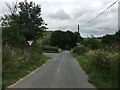
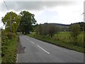
5

Minor road descending towards Paddockhole
Looking southward.
Image: © Peter Wood
Taken: 2 Oct 2021
0.15 miles
6
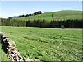
Pasture field
Viewed from a minor road with Raven's Hill in the background.
Image: © Walter Baxter
Taken: 21 May 2007
0.19 miles
7
B7068 at Paddockhole
Looking east towards Langholm, eventually.
Image: © M J Richardson
Taken: 2 Oct 2021
0.19 miles