IMAGES TAKEN NEAR TO
LOCKERBIE, DG11 2PL
Introduction
This page details the photographs taken nearby to DG11 2PL by members of the Geograph project.
The Geograph project started in 2005 with the aim of publishing, organising and preserving representative images for every square kilometre of Great Britain, Ireland and the Isle of Man.

There are currently over 7.5m images from over14,400 individuals and you can help contribute to the project by visiting https://www.geograph.org.uk
Image Map
Images are licensed for reuse under creativecommons.org/licenses/by-sa/2.0
Notes
- Clicking on the map will re-center to the selected point.
- The higher the marker number, the further away the image location is from the centre of the postcode.
Image Listing (8 Images Found)
Images are licensed for reuse under creativecommons.org/licenses/by-sa/2.0
Image
Details
Distance
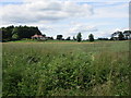
2

View near Rosebank Lodge
Looking towards Little Cleuch, the line of which is marked by the trees. (Cleuch is a variant of clough - a ravine or steep side valley.)
Image: © Jonathan Thacker
Taken: 15 Jul 2015
0.10 miles
3
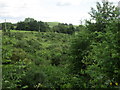
Scroggs Cleuch
Cleuch/clough - a ravine or steep sided valley.
Image: © Jonathan Thacker
Taken: 15 Jul 2015
0.17 miles
4

Gate into a field near Scalescleuch Bridge
Image: © Jonathan Thacker
Taken: 15 Jul 2015
0.18 miles

6

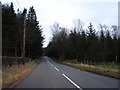
View towards Tundergarth
Tundergarth itself is hidden towards the centre of the picture but this gives a good impression of this rolling attractive countryside.
Image: © Jonathan Thacker
Taken: 15 Jul 2015
0.19 miles
7

Looking down from Scalesceuch Bridge
The point where the Scalescleuch Burn joins the Water of Milk.
Image: © Jonathan Thacker
Taken: 15 Jul 2015
0.23 miles