
IMAGES TAKEN NEAR TO
Corrie, LOCKERBIE, DG11 2NT
Introduction
This page details the photographs taken nearby to DG11 2NT by members of the Geograph project.
The Geograph project started in 2005 with the aim of publishing, organising and preserving representative images for every square kilometre of Great Britain, Ireland and the Isle of Man.

There are currently over 7.5m images from over14,400 individuals and you can help contribute to the project by visiting https://www.geograph.org.uk
Image Map
Images are licensed for reuse under creativecommons.org/licenses/by-sa/2.0
Notes
- Clicking on the map will re-center to the selected point.
- The higher the marker number, the further away the image location is from the centre of the postcode.
Image Listing (9 Images Found)
Images are licensed for reuse under creativecommons.org/licenses/by-sa/2.0
Image
Details
Distance
1
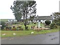
Mirrenhill Cottages
With an eclectic display of garden ornaments.
Image: © Oliver Dixon
Taken: 14 Oct 2018
0.01 miles
2
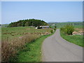
Mirrenhill Cottages
The semi-detached cottages are situated at the top of Mirrenhill on the Boreland-Corrie Common road that climbs up from the Corrie Water valley below.
Image: © Chris Newman
Taken: 13 May 2008
0.01 miles
3
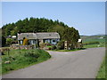
Mirrenhill Wares
Small collection of well made garden furniture on display at Mirrenhill Cottages near Corrie Common.
Image: © Chris Newman
Taken: 13 May 2008
0.01 miles
4

Mirrenhill Cottages
Track serving rough grazing, the surrounding land is rather wet.
Image: © Richard Webb
Taken: 8 Oct 2015
0.02 miles
5

Rough grazing near Corrie
A track, sometimes waterlogged makes easier going of some rough ground.
Image: © Richard Webb
Taken: 8 Oct 2015
0.04 miles
6

Rough grazing near Corrie
Wetland rough grazing below Corrie Common.
Image: © Richard Webb
Taken: 8 Oct 2015
0.11 miles
7

Rough grazing near Corrie
Wetland pasture below Corrie Common.
Image: © Richard Webb
Taken: 8 Oct 2015
0.13 miles
8
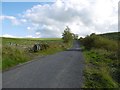
Climb to Corrie Common
The road passes a woodland with young spruce on the way up to Corrie Common from the crossing of the Heithat Burn and Corrie Water.
Image: © Richard Webb
Taken: 8 Oct 2015
0.15 miles
9

Rough grazing in Annandale
A large rough grazing area to the northeast of Mirrenhill Cottages.
Image: © Walter Baxter
Taken: 20 Jun 2009
0.22 miles