IMAGES TAKEN NEAR TO
Sibbaldbie, LOCKERBIE, DG11 2JY
Introduction
This page details the photographs taken nearby to DG11 2JY by members of the Geograph project.
The Geograph project started in 2005 with the aim of publishing, organising and preserving representative images for every square kilometre of Great Britain, Ireland and the Isle of Man.

There are currently over 7.5m images from over14,400 individuals and you can help contribute to the project by visiting https://www.geograph.org.uk
Image Map
Images are licensed for reuse under creativecommons.org/licenses/by-sa/2.0
Notes
- Clicking on the map will re-center to the selected point.
- The higher the marker number, the further away the image location is from the centre of the postcode.
Image Listing (4 Images Found)
Images are licensed for reuse under creativecommons.org/licenses/by-sa/2.0
Image
Details
Distance
1
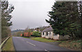
Roadside cottage
The road is the B723, in this direction, heading towards Lockerbie.
Image: © Richard Dorrell
Taken: 9 Mar 2014
0.11 miles
2
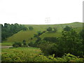
Looking towards Hewke Hill
Looking eastwards, over Dryfe Water.
Image: © David Medcalf
Taken: 17 Aug 2006
0.19 miles
3
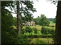
Hewke
Looking north east from the B723.
Image: © David Medcalf
Taken: 17 Aug 2006
0.21 miles
4
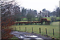
Hewke
Viewed from its entrance from the B723, Hewke is a country house standing above the Dryfe Water.
Image: © Richard Dorrell
Taken: 9 Mar 2014
0.22 miles