IMAGES TAKEN NEAR TO
High Street, LOCKERBIE, DG11 2JL
Introduction
This page details the photographs taken nearby to High Street, DG11 2JL by members of the Geograph project.
The Geograph project started in 2005 with the aim of publishing, organising and preserving representative images for every square kilometre of Great Britain, Ireland and the Isle of Man.

There are currently over 7.5m images from over14,400 individuals and you can help contribute to the project by visiting https://www.geograph.org.uk
Image Map
Images are licensed for reuse under creativecommons.org/licenses/by-sa/2.0
Notes
- Clicking on the map will re-center to the selected point.
- The higher the marker number, the further away the image location is from the centre of the postcode.
Image Listing (200 Images Found)
Images are licensed for reuse under creativecommons.org/licenses/by-sa/2.0
Image
Details
Distance
1
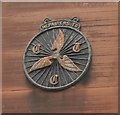
CTC Plaque
Cyclists' Touring Club (CTC) Plaque on the wall of 23 High Street, Lockerbie.
Image: © Richard Sutcliffe
Taken: 14 Jun 2019
0.01 miles
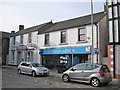
2
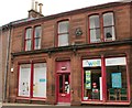
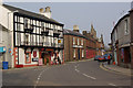
Well Pharmacy, Lockerbie
The pharmacy occupies 21-23 High Street. The building must have been a cycle shop at some stage in its history, as it has a CTC plaque on the wall [https://www.geograph.org.uk/photo/6182111], which says 'Repairers to CTC'. The building is Category B listed [http://portal.historicenvironment.scot/designation/LB37567].
Image: © Richard Sutcliffe
Taken: 14 Jun 2019
0.01 miles
3
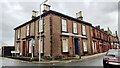
Businesses at junction of High Street and Victoria Road
#27 High Street, premises of chartered accountants Farries Kirk & McVean, has an Ordnance Survey benchmark Image on its near corner right hand face
Image: © Roger Templeman
Taken: 24 Oct 2023
0.01 miles
4
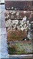
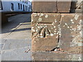
Benchmark on SE corner of #27 High Street
Ordnance Survey cut mark benchmark levelled at 81.638m above Newlyn Datum in 1974
Image: © Roger Templeman
Taken: 24 Oct 2023
0.02 miles
5
Ordnance Survey Cut Mark
This Mark can be found on a building in Townhead Street, Lockerbie.
For more detail see : http://www.bench-marks.org.uk/bm62254
Image: © Peter Wood
Taken: 21 Sep 2014
0.02 miles
8
Lockerbie
Looking along Townhead Street, the main route north out of the town.
Image: © Stephen McKay
Taken: 28 Mar 2007
0.03 miles
9
Lockerbie Library
Located at the southern end of Townhead Street. The parked cars are (right) a 2005 model Mercedes A-Class and (left) a 2005 model Toyota Corolla.
Image: © Richard Dorrell
Taken: 4 Mar 2013
0.03 miles
10
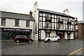
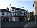
King's Arms Hotel and library, Lockerbie
The hotel is at 29 High Street and is Category C listed [http://portal.historicenvironment.scot/designation/LB37569]. DG Customer Services on the left at 31-33 provides a range of Dumfries and Galloway council and library services, including registration.
Image: © Richard Sutcliffe
Taken: 14 Jun 2019
0.03 miles