IMAGES TAKEN NEAR TO
Ferguson Place, LOCKERBIE, DG11 2HU
Introduction
This page details the photographs taken nearby to Ferguson Place, DG11 2HU by members of the Geograph project.
The Geograph project started in 2005 with the aim of publishing, organising and preserving representative images for every square kilometre of Great Britain, Ireland and the Isle of Man.

There are currently over 7.5m images from over14,400 individuals and you can help contribute to the project by visiting https://www.geograph.org.uk
Image Map
Images are licensed for reuse under creativecommons.org/licenses/by-sa/2.0
Notes
- Clicking on the map will re-center to the selected point.
- The higher the marker number, the further away the image location is from the centre of the postcode.
Image Listing (116 Images Found)
Images are licensed for reuse under creativecommons.org/licenses/by-sa/2.0
Image
Details
Distance
3
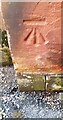
Benchmark on NE face of #60 Bridge Street
Ordnance Survey cut mark benchmark levelled at 87.499m above Newlyn Datum in 1973
Image: © Roger Templeman
Taken: 24 Oct 2023
0.04 miles
5
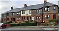
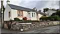
Houses on NW side of Bridge Street
There is an Ordnance Survey benchmark Image on the side of the right hand house at its front corner
Image: © Roger Templeman
Taken: 24 Oct 2023
0.05 miles
6
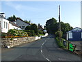
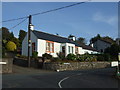
Tundergarth Road, Lockerbie (B7068)
Looking south.
Image: © JThomas
Taken: 3 Oct 2015
0.05 miles
7
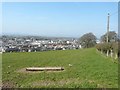
View of Lockerbie
From a field beside Tundergarth Road (B7068)
Image: © John Baker
Taken: 28 Mar 2012
0.09 miles
9
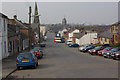
Bridge Street, Lockerbie
Looking down towards the town centre. The tower of the town hall is a prominent landmark.
Image: © Stephen McKay
Taken: 28 Mar 2007
0.10 miles
10
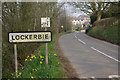
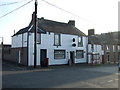
Approaching Lockerbie
Entering Lockerbie on the B7068 from Langholm. The road takes a sharp turn to the left a short distance ahead and the old style road sign still shows it as the A709, although it has downgraded to B road status for many years.
Image: © Stephen McKay
Taken: 28 Mar 2007
0.11 miles