IMAGES TAKEN NEAR TO
Rosebank Crescent, LOCKERBIE, DG11 2HJ
Introduction
This page details the photographs taken nearby to Rosebank Crescent, DG11 2HJ by members of the Geograph project.
The Geograph project started in 2005 with the aim of publishing, organising and preserving representative images for every square kilometre of Great Britain, Ireland and the Isle of Man.

There are currently over 7.5m images from over14,400 individuals and you can help contribute to the project by visiting https://www.geograph.org.uk
Image Map
Images are licensed for reuse under creativecommons.org/licenses/by-sa/2.0
Notes
- Clicking on the map will re-center to the selected point.
- The higher the marker number, the further away the image location is from the centre of the postcode.
Image Listing (18 Images Found)
Images are licensed for reuse under creativecommons.org/licenses/by-sa/2.0
Image
Details
Distance
1
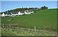
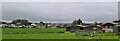
Farmland at Lockerbie
Approaching Lockerbie on a Glasgow bound train from Manchester Airport. The houses are on Rosebank Crescent.
Image: © Thomas Nugent
Taken: 18 Apr 2014
0.06 miles
2
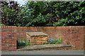
A Lockerbie Air Disaster Memorial
Set in a recess on the west side of Rosebank Crescent to commemorate the people who lost their lives in the air disaster of December 1988. A plaque has the following inscription:-
In
Remembrance
of
all victims of
Lockerbie Air Disaster
who died here on
21st December 1988
Image: © Walter Baxter
Taken: 24 Jun 2009
0.07 miles
4
Tundergarth Road, Lockerbie
A panoramic view of Lockerbie is available from the B7068 Tundergarth Road from Langholm, as it approaches the town.
Image: © Stephen McKay
Taken: 28 Mar 2007
0.14 miles
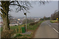
5
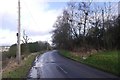
Tundergarth Road
The B7068 climbs away from Lockerbie.
Image: © Richard Webb
Taken: 5 Mar 2017
0.16 miles
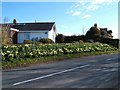
6
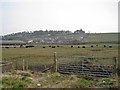
Rural Lockerbie
Houses on the east side of Carlisle Road back onto farmland currently in use as cattle pasture. The observant will notice two empty bottles standing on the gate post. I can only assume a late night reveler paused a while to share a beer with one or two of the cattle.
Image: © Richard Dorrell
Taken: 4 Mar 2013
0.18 miles
7
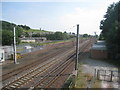
The railway south of Lockerbie station
There are both up and down passing loops.
Image: © Jonathan Thacker
Taken: 22 Jul 2013
0.21 miles
10
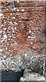
Benchmark on west face southwest angle of #4 Carlisle Road
Ordnance Survey cut mark benchmark levelled at 74.337m above Newlyn Datum in 1972 but subsequently recorded as destroyed
Image: © Roger Templeman
Taken: 24 Oct 2023
0.23 miles