IMAGES TAKEN NEAR TO
Quaas Loaning, LOCKERBIE, DG11 2DP
Introduction
This page details the photographs taken nearby to Quaas Loaning, DG11 2DP by members of the Geograph project.
The Geograph project started in 2005 with the aim of publishing, organising and preserving representative images for every square kilometre of Great Britain, Ireland and the Isle of Man.

There are currently over 7.5m images from over14,400 individuals and you can help contribute to the project by visiting https://www.geograph.org.uk
Image Map
Images are licensed for reuse under creativecommons.org/licenses/by-sa/2.0
Notes
- Clicking on the map will re-center to the selected point.
- The higher the marker number, the further away the image location is from the centre of the postcode.
Image Listing (36 Images Found)
Images are licensed for reuse under creativecommons.org/licenses/by-sa/2.0
Image
Details
Distance
1
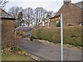
Signpost for walkers
This signpost is at the junction between the Carlisle Road and a minor road named Quaas Loaning. Turnmuir is a forestry plantation. Quaas Loaning is an ancient route, but has been cut in two by the building of the A74(M). Pedestrians cross the main road via a footbridge, and Quaas Loaning then continues as a farm track.
Image: © Richard Dorrell
Taken: 4 Mar 2013
0.02 miles
2
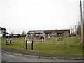
Playpark in Quaas Loaning
A lack of children using the facilities within the playpark is not unusual. But the name of the location must rank highly among the oddest street names in the UK.
Image: © Richard Dorrell
Taken: 4 Mar 2013
0.03 miles
3
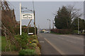
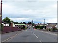
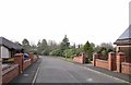
Carlisle Road, Lockerbie
The main approach into Lockerbie from the south.
Image: © Stephen McKay
Taken: 28 Mar 2007
0.04 miles
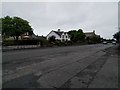
5
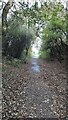
Quaas Loaning footpath heading east towards Carlisle Road
Image: © Luke Shaw
Taken: 24 Oct 2023
0.05 miles
8
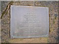
Sherwood Crescent memorial plaque
Close up of the plaque in the memorial garden in Sherwood Crescent. Wider view and more information: Image
Image: © Richard Dorrell
Taken: 4 Mar 2013
0.10 miles
9
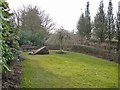
Sherwood Crescent memorial garden
A lawned garden with shrubs and trees now occupies the site where numbers 13 to 16 Sherwood Crescent once stood. The homes were destroyed (together with several other local houses) on Wednesday, 21 December 1988 when a large section of a Boeing 747–121 airliner crashed to earth here. The plane was destroyed by an explosive device. The explosion and crash killed all 243 passengers and 16 crew members in the plane and a further 11 people on the ground. Memorial plaque detail: Image
Image: © Richard Dorrell
Taken: 4 Mar 2013
0.10 miles
10
Sherwood Crescent, Lockerbie
A gap in the houses in Sherwood Crescent, which is now an attractive memorial garden of lawn and shrubs, is the spot where on Wednesday 21st December 1988, a large section of a Boeing 747–121 airliner crashed to the ground, having been destroyed by an explosive device. The incident killed all 243 passengers and 16 crew members on board the plane and a further 11 people on the ground. Within the garden: Image
Image: © Richard Dorrell
Taken: 4 Mar 2013
0.10 miles