
IMAGES TAKEN NEAR TO
Victoria Court, LOCKERBIE, DG11 2BU
Introduction
This page details the photographs taken nearby to Victoria Court, DG11 2BU by members of the Geograph project.
The Geograph project started in 2005 with the aim of publishing, organising and preserving representative images for every square kilometre of Great Britain, Ireland and the Isle of Man.

There are currently over 7.5m images from over14,400 individuals and you can help contribute to the project by visiting https://www.geograph.org.uk
Image Map
Images are licensed for reuse under creativecommons.org/licenses/by-sa/2.0
Notes
- Clicking on the map will re-center to the selected point.
- The higher the marker number, the further away the image location is from the centre of the postcode.
Image Listing (198 Images Found)
Images are licensed for reuse under creativecommons.org/licenses/by-sa/2.0
Image
Details
Distance
1
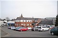
Lockerbie Medical Practice
Located in Victoria Gardens. The Practice is a partnership of four doctors working together with the school nursing team, community paediatricians, midwives, physiotherapists and podiatrists.
Image: © Richard Dorrell
Taken: 4 Mar 2013
0.03 miles
2

Boundary of Victoria Park
Here, a brick wall with iron railings separates Victoria Park from a car park. The clock tower of the Town Hall is prominent in the background.
Image: © Richard Dorrell
Taken: 4 Mar 2013
0.05 miles
3
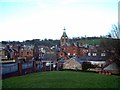
Lockerbie
The clock tower in the centre of the picture belongs to the Town Hall, which was built in 1891 in the Scottish baronial style. The town hall also features a war memorial which has a statue of a winged figure.
Image: © Lynne Kirton
Taken: 19 Apr 2006
0.06 miles
4
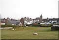
Urban pasture
These two sheep look content in a small pasture which is just a stone's throw from Lockerbie town centre.
Image: © Richard Dorrell
Taken: 4 Mar 2013
0.06 miles
5
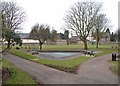
Paddling Pool in Victoria Park, Lockerbie
This small park on Banks Hill, close to the centre of Lockerbie, includes a children's play area which is currently being refurbished. The paddling pool pictured (and closed just now, it being winter) was opened 12th June 1964, having been gifted to the Burgh by the daughters of the late David McJerrow. Detail of plaque set in ground beside path: Image
Image: © Richard Dorrell
Taken: 4 Mar 2013
0.07 miles
6
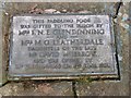
Paddling pool plaque
This plaque is set into the ground close to the paddling pool to which it refers. See also: Image] .
Image: © Richard Dorrell
Taken: 4 Mar 2013
0.07 miles
7
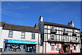
Lockerbie Library and King's Arms Hotel
Image: © Leslie Barrie
Taken: 11 Jun 2015
0.07 miles
8
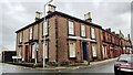
Businesses at junction of High Street and Victoria Road
#27 High Street, premises of chartered accountants Farries Kirk & McVean, has an Ordnance Survey benchmark Image on its near corner right hand face
Image: © Roger Templeman
Taken: 24 Oct 2023
0.08 miles
9
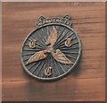
CTC Plaque
Cyclists' Touring Club (CTC) Plaque on the wall of 23 High Street, Lockerbie.
Image: © Richard Sutcliffe
Taken: 14 Jun 2019
0.08 miles
10
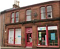
Well Pharmacy, Lockerbie
The pharmacy occupies 21-23 High Street. The building must have been a cycle shop at some stage in its history, as it has a CTC plaque on the wall [https://www.geograph.org.uk/photo/6182111], which says 'Repairers to CTC'. The building is Category B listed [http://portal.historicenvironment.scot/designation/LB37567].
Image: © Richard Sutcliffe
Taken: 14 Jun 2019
0.08 miles