IMAGES TAKEN NEAR TO
LOCKERBIE, DG11 1LW
Introduction
This page details the photographs taken nearby to DG11 1LW by members of the Geograph project.
The Geograph project started in 2005 with the aim of publishing, organising and preserving representative images for every square kilometre of Great Britain, Ireland and the Isle of Man.

There are currently over 7.5m images from over14,400 individuals and you can help contribute to the project by visiting https://www.geograph.org.uk
Image Map
Images are licensed for reuse under creativecommons.org/licenses/by-sa/2.0
Notes
- Clicking on the map will re-center to the selected point.
- The higher the marker number, the further away the image location is from the centre of the postcode.
Image Listing (5 Images Found)
Images are licensed for reuse under creativecommons.org/licenses/by-sa/2.0
Image
Details
Distance
1
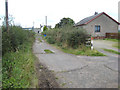
Cottage at Priestdykes
Just off the A709 Lockerbie to Dumfries road.
Image: © Oliver Dixon
Taken: 28 Sep 2007
0.00 miles
2
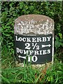
Old Milestone by the A709, Priestdykes
Stone post with metal plate by the A709, in parish of Lochmaben (Annandale District), Priestdykes, on long straight NW of dairy entrance, North East side of road.
Inscription reads:- : LOCKERBY / 2½ {arrow} / DUMFRIES / {arrow} 10 :
Surveyed
Milestone Society National ID: DG_DFLB10.
Image: © Milestone Society
Taken: Unknown
0.04 miles
3
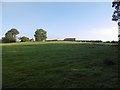
Field, Priestdykes
A lorry is parked up on the road into the creamery.
Image: © Richard Webb
Taken: 8 Oct 2015
0.08 miles
5
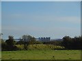
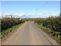
Field near Lochmaben
Looking in the direction of the creamery.
Image: © Richard Webb
Taken: 8 Oct 2015
0.24 miles