IMAGES TAKEN NEAR TO
Rankine Heights, LOCKERBIE, DG11 1LJ
Introduction
This page details the photographs taken nearby to Rankine Heights, DG11 1LJ by members of the Geograph project.
The Geograph project started in 2005 with the aim of publishing, organising and preserving representative images for every square kilometre of Great Britain, Ireland and the Isle of Man.

There are currently over 7.5m images from over14,400 individuals and you can help contribute to the project by visiting https://www.geograph.org.uk
Image Map (Loading...)


Getting Data...Please wait
Leaflet Map data © OpenStreetMap
Images are licensed for reuse under creativecommons.org/licenses/by-sa/2.0
Notes
- Clicking on the map will re-center to the selected point.
- The higher the marker number, the further away the image location is from the centre of the postcode.
Image Listing (11 Images Found)
Images are licensed for reuse under creativecommons.org/licenses/by-sa/2.0
Image
Details
Distance
1
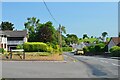
Road leaving Lochmaben
The B7020 heading north out of Lochmaben.
Image: © Jim Barton
Taken: 17 Jul 2021
0.04 miles
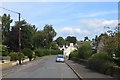
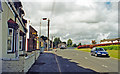
3
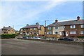
Marjoriebanks
Residential road, Lochmaben
Image: © Richard Webb
Taken: 17 Aug 2015
0.09 miles
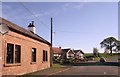
5
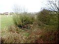
Dumfries, Lochmaben and Lockerbie Railway (disused)
Image: © Les Hull
Taken: 12 Mar 2017
0.19 miles
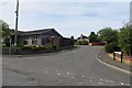
6
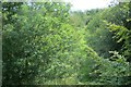
Dumfries, Lochmaben and Lockerbie Railway
Looking east towards the site of Lochmaben Station, closed in the 1960s.
Image: © Richard Webb
Taken: 17 Aug 2015
0.19 miles
7
Lochmaben: site of former station, 2000
View northward on the B7020: Lochmaben station (closed to passengers 19/5/52, to goods 4/5/64) had been on the left, on the ex-Caledonian Railway Lockerbie (to right) - Dumfries line (closed 18/4/66) that passed under the road here.
Image: © Ben Brooksbank
Taken: 21 Jun 2000
0.20 miles
8
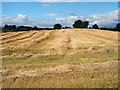
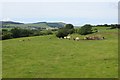
Arable farming
Harvesting of crops at farmland near Lochmaben
Image: © Norma Foggo
Taken: 10 Aug 2005
0.21 miles
9
Mossvale, Lochmaben
Houses overlooking the Mill Loch
Image: © Richard Webb
Taken: 17 Aug 2015
0.22 miles
10
Dumfries, Lochmaben and Lockerbie Railway
The site of the trackbed, west of Lochmaben.
Image: © Richard Webb
Taken: 17 Aug 2015
0.24 miles