IMAGES TAKEN NEAR TO
Johnstonebridge, LOCKERBIE, DG11 1EP
Introduction
This page details the photographs taken nearby to DG11 1EP by members of the Geograph project.
The Geograph project started in 2005 with the aim of publishing, organising and preserving representative images for every square kilometre of Great Britain, Ireland and the Isle of Man.

There are currently over 7.5m images from over14,400 individuals and you can help contribute to the project by visiting https://www.geograph.org.uk
Image Map (Loading...)


Getting Data...Please wait
Leaflet Map data © OpenStreetMap
Images are licensed for reuse under creativecommons.org/licenses/by-sa/2.0
Notes
- Clicking on the map will re-center to the selected point.
- The higher the marker number, the further away the image location is from the centre of the postcode.
Image Listing (4 Images Found)
Images are licensed for reuse under creativecommons.org/licenses/by-sa/2.0
Image
Details
Distance
2
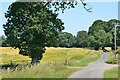
Annandale Way near Lochbrow
The Way leaves the minor road for the track heading over North Lochbrowmoor.
Image: © Jim Barton
Taken: 17 Jul 2021
0.16 miles
3
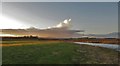
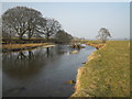
River Annan at Lochbrow
Clouds building up over Queensberry Hill on a february afternoon.
Image: © Thomas Dick
Taken: 22 Feb 2016
0.24 miles
4
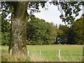
Benetthill Plantation
A wood beyond a field and roadside oak.
Image: © Richard Webb
Taken: 8 Oct 2015
0.24 miles