IMAGES TAKEN NEAR TO
LOCKERBIE, DG11 1BW
Introduction
This page details the photographs taken nearby to DG11 1BW by members of the Geograph project.
The Geograph project started in 2005 with the aim of publishing, organising and preserving representative images for every square kilometre of Great Britain, Ireland and the Isle of Man.

There are currently over 7.5m images from over14,400 individuals and you can help contribute to the project by visiting https://www.geograph.org.uk
Image Map
Images are licensed for reuse under creativecommons.org/licenses/by-sa/2.0
Notes
- Clicking on the map will re-center to the selected point.
- The higher the marker number, the further away the image location is from the centre of the postcode.
Image Listing (3 Images Found)
Images are licensed for reuse under creativecommons.org/licenses/by-sa/2.0
Image
Details
Distance
1
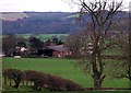
Roberthill, near Lockerbie
The Dumfries & Galloway area was hard-hit during the foot and mouth crisis. At Roberthill 592 cattle and 380 sheep were slaughtered.
Image: © Lynne Kirton
Taken: 28 Mar 2005
0.17 miles
3
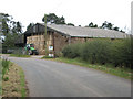
A well-stocked barn
At Roberthill Farm, near Lockerbie.
Image: © Oliver Dixon
Taken: 28 Sep 2007
0.23 miles