IMAGES TAKEN NEAR TO
LOCKERBIE, DG11 1BS
Introduction
This page details the photographs taken nearby to DG11 1BS by members of the Geograph project.
The Geograph project started in 2005 with the aim of publishing, organising and preserving representative images for every square kilometre of Great Britain, Ireland and the Isle of Man.

There are currently over 7.5m images from over14,400 individuals and you can help contribute to the project by visiting https://www.geograph.org.uk
Image Map
Images are licensed for reuse under creativecommons.org/licenses/by-sa/2.0
Notes
- Clicking on the map will re-center to the selected point.
- The higher the marker number, the further away the image location is from the centre of the postcode.
Image Listing (10 Images Found)
Images are licensed for reuse under creativecommons.org/licenses/by-sa/2.0
Image
Details
Distance
6
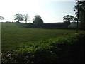
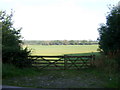
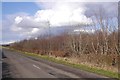
View of Burnswark
A field surrounded by woodland gives a view to the fort topped hill from the B723. The motorway is out of sight but can be heard from here, the railway was nearly silent due to engineering works.
Image: © Richard Webb
Taken: 5 Mar 2017
0.12 miles
8
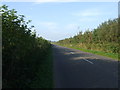
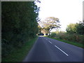
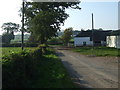
Heading north towards Lockerbie
On the B723.
Image: © JThomas
Taken: 3 Oct 2015
0.21 miles
9
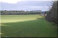
Halfmoon plantation
Youngish at the moment and as the name suggests, its half a circle in shape.
Image: © Richard Webb
Taken: 5 Mar 2017
0.21 miles