IMAGES TAKEN NEAR TO
Hoddom, LOCKERBIE, DG11 1AN
Introduction
This page details the photographs taken nearby to DG11 1AN by members of the Geograph project.
The Geograph project started in 2005 with the aim of publishing, organising and preserving representative images for every square kilometre of Great Britain, Ireland and the Isle of Man.

There are currently over 7.5m images from over14,400 individuals and you can help contribute to the project by visiting https://www.geograph.org.uk
Image Map (Loading...)


Getting Data...Please wait
Leaflet Map data © OpenStreetMap
Images are licensed for reuse under creativecommons.org/licenses/by-sa/2.0
Notes
- Clicking on the map will re-center to the selected point.
- The higher the marker number, the further away the image location is from the centre of the postcode.
Image Listing (2 Images Found)
Images are licensed for reuse under creativecommons.org/licenses/by-sa/2.0
Image
Details
Distance
1
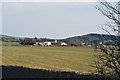
Mainholme Farm on the Hoddom Estate
Woodcock Hill in the distance
Image: © Mike and Kirsty Grundy
Taken: 31 Mar 2007
0.15 miles
2
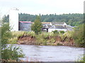
Mainholm Farm
Large farm with tall silage tower. Seen across the River Annan from Hoddom Castle Golf Course. The outer bend of the Annan here has a high and steep bank of red sandstone earth.
Image: © Colin Smith
Taken: 1 Sep 2009
0.22 miles