IMAGES TAKEN NEAR TO
Middleshaw, LOCKERBIE, DG11 1AJ
Introduction
This page details the photographs taken nearby to DG11 1AJ by members of the Geograph project.
The Geograph project started in 2005 with the aim of publishing, organising and preserving representative images for every square kilometre of Great Britain, Ireland and the Isle of Man.

There are currently over 7.5m images from over14,400 individuals and you can help contribute to the project by visiting https://www.geograph.org.uk
Image Map
Images are licensed for reuse under creativecommons.org/licenses/by-sa/2.0
Notes
- Clicking on the map will re-center to the selected point.
- The higher the marker number, the further away the image location is from the centre of the postcode.
Image Listing (11 Images Found)
Images are licensed for reuse under creativecommons.org/licenses/by-sa/2.0
Image
Details
Distance
1
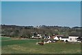
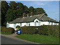
Middleshaw
Hamlet on the B723 from Annan to Lockerbie (Do the Scots use the term hamlet? If not, what?)
Image: © Mike and Kirsty Grundy
Taken: 1 Apr 2007
0.06 miles
2
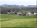
Middleshaw
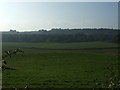
Hamlet overlooking the valley of the River Annan.
Image: © Oliver Dixon
Taken: 17 Mar 2014
0.07 miles
3
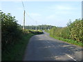
A twisty B723 near Middleshaw
Heading north towards Lockerbie.
Image: © JThomas
Taken: 3 Oct 2015
0.10 miles
4
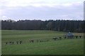
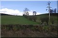
Middleshaw
Looking down to a haugh beside the Water of Milk from the road.
Image: © Richard Webb
Taken: 5 Mar 2017
0.13 miles
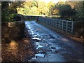
7
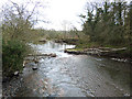
Water of Milk at Middleshaw
Looking downstream to a small weir.
Image: © Oliver Dixon
Taken: 17 Mar 2014
0.22 miles
10

Annandale Way and no through road to Broom
Image: © Steven Brown
Taken: 24 Oct 2013
0.24 miles