IMAGES TAKEN NEAR TO
Clint Terrace, LOCKERBIE, DG11 1AF
Introduction
This page details the photographs taken nearby to Clint Terrace, DG11 1AF by members of the Geograph project.
The Geograph project started in 2005 with the aim of publishing, organising and preserving representative images for every square kilometre of Great Britain, Ireland and the Isle of Man.

There are currently over 7.5m images from over14,400 individuals and you can help contribute to the project by visiting https://www.geograph.org.uk
Image Map
Images are licensed for reuse under creativecommons.org/licenses/by-sa/2.0
Notes
- Clicking on the map will re-center to the selected point.
- The higher the marker number, the further away the image location is from the centre of the postcode.
Image Listing (11 Images Found)
Images are licensed for reuse under creativecommons.org/licenses/by-sa/2.0
Image
Details
Distance
1
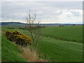
B7076 roadside
A grassy bank, with Gorse and an Ash sapling, slopes down to grass field at Mainhill farm.
Image: © M J Richardson
Taken: 26 Apr 2022
0.16 miles

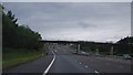
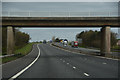
4
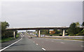
Bridge carrying a farm track over the A74(M)
Image: © Peter Bond
Taken: 30 Sep 2011
0.20 miles
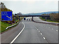
9
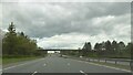
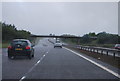
Dumfries and Galloway : The A74(M) Motorway
Heading along the A74(M).
Image: © Lewis Clarke
Taken: 22 Apr 2016
0.20 miles
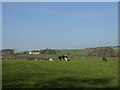
10
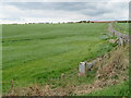
Pasture at Mainhill farm
And the road to the farm and a watering cistern.
Image: © M J Richardson
Taken: 26 Apr 2022
0.23 miles