IMAGES TAKEN NEAR TO
Harthope Place, MOFFAT, DG10 9HX
Introduction
This page details the photographs taken nearby to Harthope Place, DG10 9HX by members of the Geograph project.
The Geograph project started in 2005 with the aim of publishing, organising and preserving representative images for every square kilometre of Great Britain, Ireland and the Isle of Man.

There are currently over 7.5m images from over14,400 individuals and you can help contribute to the project by visiting https://www.geograph.org.uk
Image Map
Images are licensed for reuse under creativecommons.org/licenses/by-sa/2.0
Notes
- Clicking on the map will re-center to the selected point.
- The higher the marker number, the further away the image location is from the centre of the postcode.
Image Listing (128 Images Found)
Images are licensed for reuse under creativecommons.org/licenses/by-sa/2.0
Image
Details
Distance
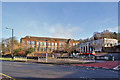
1
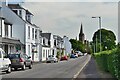
Approaching Moffat from the north
The spire marks the former St Mary's Church, now converted to apartments.
Image: © Jim Barton
Taken: 19 Jul 2021
0.06 miles
4
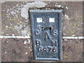
Ordnance Survey Flush Bracket G476
This can be found on the wall of the former Academy.
For more detail see : http://www.bench-marks.org.uk/bm10766
Image: © Peter Wood
Taken: 28 Sep 2012
0.07 miles
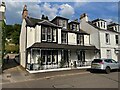
5
Moffat Academy (Former)
The Academy occupied this site from 1834. The main building seen here was built 1932. The Academy moved in to new premises off the Holm Road in January 2010. (See Image]). The site photographed is currently disused. The Dumfries and Galloway Planning Office suggests that the site should be redeveloped for mixed use, possibly including small business and residential units. The main building is listed.
Image: © Richard Dorrell
Taken: 10 Mar 2014
0.07 miles
6
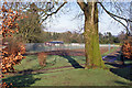
Beechgrove Recreation Ground
The tennis courts are used by the Beechgrove Tennis Club.
Image: © Richard Dorrell
Taken: 10 Mar 2014
0.08 miles
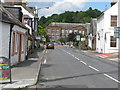
7
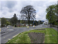
Edinburgh Road/Beechgrove
The fork in the road at the northern end of Moffat town centre. To the left is the A701, Edinburgh Road; to the right is Beechgrove (Old Edinburgh Road).
Image: © David Dixon
Taken: 16 Apr 2012
0.08 miles
8
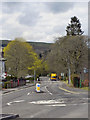
Edinburgh Road (A701), Moffat
Looking along Edinburgh Road from its junction with Beechgrove.
Image: © David Dixon
Taken: 16 Apr 2012
0.09 miles
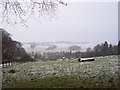
9
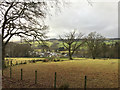
Fields north of Moffat
Looking down the lower slopes of Gallowhill.
Image: © John Allan
Taken: 3 Feb 2017
0.09 miles
10
Moffat, A 701
Leaving Moffat to the North.
Image: © G Laird
Taken: 13 Aug 2008
0.10 miles