
IMAGES TAKEN NEAR TO
The Copse, ILKESTON, DE7 8TT
Introduction
This page details the photographs taken nearby to The Copse, DE7 8TT by members of the Geograph project.
The Geograph project started in 2005 with the aim of publishing, organising and preserving representative images for every square kilometre of Great Britain, Ireland and the Isle of Man.

There are currently over 7.5m images from over14,400 individuals and you can help contribute to the project by visiting https://www.geograph.org.uk
Image Map
Images are licensed for reuse under creativecommons.org/licenses/by-sa/2.0
Notes
- Clicking on the map will re-center to the selected point.
- The higher the marker number, the further away the image location is from the centre of the postcode.
Image Listing (10 Images Found)
Images are licensed for reuse under creativecommons.org/licenses/by-sa/2.0
Image
Details
Distance


3
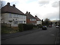
Houses on Langley Avenue, Cotmanhay Farm estate
Very boxy looking houses with an unusually large quantity of small windows.
Image: © Richard Vince
Taken: 24 Feb 2015
0.18 miles
4
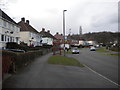
Beauvale Drive, Cotmanhay Farm estate (2)
Looking north from the end of Langley Avenue towards a bus stop. There are bus stops only on one side of Beauvale Drive, as all three bus services serving the estate (The Two, Ilkeston Flyer, and Y3) do so by performing a one way loop via Beauvale Drive (clockwise) and Skeavingtons Lane.
Image: © Richard Vince
Taken: 24 Feb 2015
0.19 miles
5
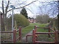
Footpath off Langley Avenue, Cotmanhay Farm estate
Heading across a playing field towards Ilkeston.
Image: © Richard Vince
Taken: 24 Feb 2015
0.19 miles

7

Cotmanhay Wood from Long Lane
The main road between Ilkeston and Heanor almost diagonally bisects the square and from the mid point, the aptly named Long Lane runs down to the former Shipley Gate Railway Station. Seen here looking to the east from the lane is Cotmanhay Wood. Bentley's Plantation, another wooded area is across the farmland to the west.
Image: © Garth Newton
Taken: 7 Sep 2005
0.20 miles
8

Long Lane, Shipley
Long Lane leads down to Shipley Gate and is a public footpath but not a public road. The sign makes the legal position clear.
Image: © Stephen McKay
Taken: 23 Feb 2014
0.21 miles
9

Hassock Lane South
The A6007 changes its name frequently and here is Hassock Lane South.
Image: © Malcolm Neal
Taken: 6 May 2021
0.21 miles
10

Long Lane
A private road and public footpath.
Image: © David Lally
Taken: 20 Nov 2020
0.22 miles