IMAGES TAKEN NEAR TO
Cotmanhay Road, ILKESTON, DE7 8LL
Introduction
This page details the photographs taken nearby to Cotmanhay Road, DE7 8LL by members of the Geograph project.
The Geograph project started in 2005 with the aim of publishing, organising and preserving representative images for every square kilometre of Great Britain, Ireland and the Isle of Man.

There are currently over 7.5m images from over14,400 individuals and you can help contribute to the project by visiting https://www.geograph.org.uk
Image Map
Images are licensed for reuse under creativecommons.org/licenses/by-sa/2.0
Notes
- Clicking on the map will re-center to the selected point.
- The higher the marker number, the further away the image location is from the centre of the postcode.
Image Listing (27 Images Found)
Images are licensed for reuse under creativecommons.org/licenses/by-sa/2.0
Image
Details
Distance
1
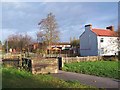
Cotmanhay Linear Park
The linear park runs along the route of an old railway line. Here where it meets Ebenezer Street there used to be a bridge over the road.
Image: © Garth Newton
Taken: 24 Nov 2004
0.05 miles
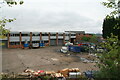
2
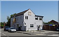
Convenience store on Charlotte Street, Ilkeston
Image: © JThomas
Taken: 29 Jun 2019
0.06 miles
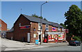
3
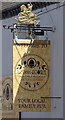
The Commercial and Little Acorn, Ilkeston
Image: © al partington
Taken: 17 Aug 2007
0.13 miles
4
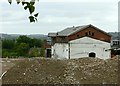
Former railway goods shed, Ilkeston
Now probably the only remaining railway building in the town itself. It survives due to being incorporated in the factory of Gardner Aerospace, but appears to be being left behind during the demolition of the latter.
Image: © Alan Murray-Rust
Taken: 28 Jul 2017
0.15 miles
5
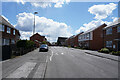
Cotmanhay Road
Now travelling along Cotmanhay Road to Ilkeston and then home.
Image: © Malcolm Neal
Taken: 6 May 2021
0.15 miles
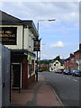
6
The Little Acorn, Ilkeston
On Awsworth Road.
Image: © JThomas
Taken: 29 Jun 2019
0.17 miles
8
Former lace factory, Ilkeston
Submerged in the middle of 1960s factory buildings are the remains of a lace factory of c1910 that formerly belonged to George Beardsley. The name Beardsley is visible on the Heanor Road side of the roof. These positions are approximate as this complex has been replaced by new houses. Other submissions suggest the modern buildings are Gardner Aerospace.
Image: © Chris Allen
Taken: 18 May 2013
0.18 miles
9
Modern works in front of an old lace factory
The slate roof peeking above the building to the right of centre belongs to a former two lace factory of c1910 and owned by George Beardsley. The name Beardsley was still visible on the roof when zoomed in closer. The 1960s building were, I believe, Gardner Aerospace. All these buildings have been cleared and replaced by a housing development.
Image: © Chris Allen
Taken: 18 May 2013
0.18 miles
10

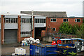
Demolition of the former Gardner Aerospace site
Next to Heanor Road in Ilkeston.
Image: © Mat Fascione
Taken: 28 Feb 2016
0.19 miles