
IMAGES TAKEN NEAR TO
Tarrat Street, ILKESTON, DE7 8GT
Introduction
This page details the photographs taken nearby to Tarrat Street, DE7 8GT by members of the Geograph project.
The Geograph project started in 2005 with the aim of publishing, organising and preserving representative images for every square kilometre of Great Britain, Ireland and the Isle of Man.

There are currently over 7.5m images from over14,400 individuals and you can help contribute to the project by visiting https://www.geograph.org.uk
Image Map
Images are licensed for reuse under creativecommons.org/licenses/by-sa/2.0
Notes
- Clicking on the map will re-center to the selected point.
- The higher the marker number, the further away the image location is from the centre of the postcode.
Image Listing (27 Images Found)
Images are licensed for reuse under creativecommons.org/licenses/by-sa/2.0
Image
Details
Distance
1
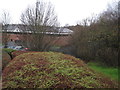
Ilkeston (North) railway station (site), Derbyshire
Opened in 1878 by the Great Northern Railway on the line from Nottingham to Derby Friargate, this station closed in 1968.
View south west from the former over-bridge towards West Hallam and Derby. The site has been completely redeveloped and no trace of the station apparently remains.
Image: © Nigel Thompson
Taken: 22 Jan 2016
0.12 miles
2
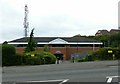
Ilkeston Police Station
Occupying the site of the former Great Northern Railway's Ilkeston (later Ilkeston North) railway station.
Image: © Alan Murray-Rust
Taken: 28 Jul 2017
0.12 miles
3
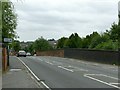
Heanor Road former railway bridge
Crossing the site of the former Great Northern Railway's Derbyshire Extension between Nottingham and Derby.
Image: © Alan Murray-Rust
Taken: 28 Jul 2017
0.15 miles
4
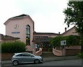
Weleda House, Heanor Road
Built in 1939 originally as Michael House School, teaching on the principles of the Austrian philosopher and natural scientist Rudolf Steiner http://www.weleda.co.uk/our-heritage/rudolf-steiner/page/rudolf-steiner . It was subsequently converted into a pharmaceutics and cosmetics factory. The unusual architecture arises from Steiner's principles of not using right angles.
Image: © Alan Murray-Rust
Taken: 28 Jul 2017
0.17 miles
5

Old Garage on Manor Road
A new-looking coat of whitewash makes it appear that these premises are still in operation. The rest of the buildings on the plot have been demolished.
Image: © David Lally
Taken: 24 Jan 2010
0.18 miles
6

Baileys Factory, now Shed 2 Studios, Ilkeston
A Grade II Listed building built in 1855 for Bailey Sons & Co, lace and hosiery manufacturers.
Image: © Chris Allen
Taken: 18 May 2013
0.19 miles
7

Baileys Factory, now Norton Plastics, Ilkeston
A Grade II Listed building built in 1855 for Bailey Sons & Co, lace and hosiery manufacturers. The block by the roadside was built between 1865 and 1879.
Image: © Chris Allen
Taken: 18 May 2013
0.19 miles
8
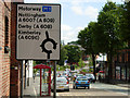
Heanor Road, Ilkeston
Traffic approaching Ilkeston on the A6007 from the north arrives at the large roundabout ahead, with a choice of proceeding via Awsworth Road, Rutland Street, Chalons Way, Bath Street or Manners Road.
Image: © Stephen McKay
Taken: 4 Jul 2008
0.19 miles
9

Former Norton Plastics factory, Heanor Road
Originally a lace and hosiery factory, the nearer building dating from around 1830, the section beyond http://www.geograph.org.uk/photo/5482893 being dated 1855, the whole being Listed Grade II. The factory has been unoccupied since 2008 when it was sold for development as apartments, although nothing appears to have happened.
Image: © Alan Murray-Rust
Taken: 28 Jul 2017
0.19 miles
10
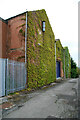
Tatham's Lane and Gardner Aerospace, Ilkeston
This works includes a two storey lace mill that was built c1910 for George Beardsley and is not visible from here. The works has now been replaced by a housing development.
Image: © Chris Allen
Taken: 18 May 2013
0.19 miles