IMAGES TAKEN NEAR TO
Grindslow Avenue, ILKESTON, DE7 6NQ
Introduction
This page details the photographs taken nearby to Grindslow Avenue, DE7 6NQ by members of the Geograph project.
The Geograph project started in 2005 with the aim of publishing, organising and preserving representative images for every square kilometre of Great Britain, Ireland and the Isle of Man.

There are currently over 7.5m images from over14,400 individuals and you can help contribute to the project by visiting https://www.geograph.org.uk
Image Map
Images are licensed for reuse under creativecommons.org/licenses/by-sa/2.0
Notes
- Clicking on the map will re-center to the selected point.
- The higher the marker number, the further away the image location is from the centre of the postcode.
Image Listing (9 Images Found)
Images are licensed for reuse under creativecommons.org/licenses/by-sa/2.0
Image
Details
Distance
1
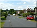
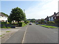
St Wilfrid's Road, West Hallam
Suburban-style development from the mid 20th century.
Image: © Alan Murray-Rust
Taken: 9 Jul 2017
0.12 miles
2
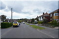
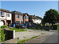
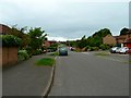
St. Wilfred's Road
St. Wilfred's Road runs along the eastern edge of West Hallam. Though even here on the fairly wide road people still park half on the road and half on the pavement.
Image: © Malcolm Neal
Taken: 29 Apr 2021
0.13 miles
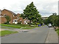
4
Chiltern Drive in West Hallam
A typical picture of one of the roads on this large housing estate in West Hallam.
Image: © Andy Farrington
Taken: 29 May 2011
0.19 miles
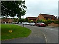
5
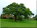
West Hallam Estate
This oak in the middle of the estate is likely to be older than the estate built just over 25 years ago.
Image: © Andy Farrington
Taken: 29 May 2011
0.19 miles
8
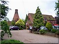
The Bottle Kiln
The Bottle Kiln is an art gallery with craft and gift shops, a buttery cafe and a Japanese Garden. It has been transformed from the original kiln on the site and an information board inside includes this:
"This site was originally an estate sawmill making pit-props for the Newdigate Estate coal mines. In the mid 19th century additional buildings were erected to house a small brick works using materials from a nearby clay pit. The bricks were fired in beehive kilns.
Two bottle-neck kilns were built by the 'West Hallam Art & Earthenware Company' in the early 1920s utilising the earlier buildings and adding further workshops and a boiler house with a square chimney. The pottery failed in 1933. One kiln was demolished in the 1950s causing local concern and the present outer kiln shell was registered as a 'listed' building.
The Stone family purchased the derelict site in 1983. Charles Stone designed and built the present complex of which only the kiln shell is an original building, with substantial help from his sons. The business here has been run by the Stone family ever since."
Image: © Garth Newton
Taken: 19 May 2006
0.21 miles
9
Derbyshire Avenue in West Hallam
View along this long road, one of several on this large estate in West Hallam built just over 25 years ago.
Image: © Andy Farrington
Taken: 29 May 2011
0.22 miles