IMAGES TAKEN NEAR TO
Hollies Farm Drive, ILKESTON, DE7 6JW
Introduction
This page details the photographs taken nearby to Hollies Farm Drive, DE7 6JW by members of the Geograph project.
The Geograph project started in 2005 with the aim of publishing, organising and preserving representative images for every square kilometre of Great Britain, Ireland and the Isle of Man.

There are currently over 7.5m images from over14,400 individuals and you can help contribute to the project by visiting https://www.geograph.org.uk
Image Map
Images are licensed for reuse under creativecommons.org/licenses/by-sa/2.0
Notes
- Clicking on the map will re-center to the selected point.
- The higher the marker number, the further away the image location is from the centre of the postcode.
Image Listing (41 Images Found)
Images are licensed for reuse under creativecommons.org/licenses/by-sa/2.0
Image
Details
Distance
1
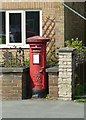
Horsley Woodhouse So postbox, ref DE7 261
Standard GVIR pillar box in its own recess in the garden wall of the house containing the Post Office.
Image: © Alan Murray-Rust
Taken: 19 Jun 2017
0.03 miles
2
Horsley Woodhouse Post Office
Occupying the front room of a private residence.
Image: © Alan Murray-Rust
Taken: 19 Jun 2017
0.03 miles
3
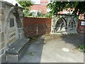
Millennium Wall, Horsley Woodhouse
The arches/windows were gathered together from the Church Hall when it was rebuilt.
Image: © Alan Murray-Rust
Taken: 19 Jun 2017
0.04 miles
4
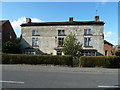
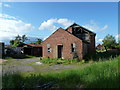
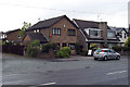
Hollies Farm
This building, a late 17th century village house which was given a stylish Regency facelift now survives as a farm in Horsley Woodhouse. Architecturally, it is about the most distinguished domestic residence in the village although now empty and due to be bulldozed to make way for new houses. Behind the farm house is an example of a tannery which can be traced back to the same period unfortunately also due for demolition. http://www.ripleyandheanornews.co.uk/news/local/housing_planned_on_tannery_site_1_723841 http://www.youandyesterday.com/articles/Tea_cheer_for_tannery_staff_with_leather_in_their_souls
Image: © Andy Farrington
Taken: 29 May 2011
0.04 miles
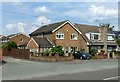
5
Hollies Farm Tannery
This tannery behind the farmhouse which can be traced back to the 1600's is due for demolition to make way for housing Image]
Image: © Andy Farrington
Taken: 29 May 2011
0.04 miles
6
Methodist Chapel and Sunday School, Horsley Woodhouse
An imposing pedimented facade. Still in active use.
Image: © Alan Murray-Rust
Taken: 19 Jun 2017
0.05 miles
7
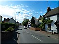
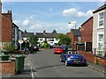
Main Street in Horsley Woodhouse
View along the main road in the village towards Four Lane Ends, right of picture is the Woodhouse Stores still showing a yellow Double Diamond Free Off Licence sign above the store name. A Double Diamond works wonders so drink one today!
Image: © Andy Farrington
Taken: 29 May 2011
0.06 miles
8
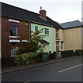
Terraced cottages
Individually coloured walls in Horsley Woodhouse.
Image: © Peter Barr
Taken: 26 Nov 2012
0.06 miles
9
Fairfield Road, Horsley Woodhouse
The principal 'back' street of this essentially linear village.
Image: © Alan Murray-Rust
Taken: 19 Jun 2017
0.06 miles
10
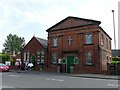
Horsley Woodhouse Post Office
Horsley Woodhouse Post Office, A609, Horsley Woodhouse, Derbyshire, opposite the Central Methodist Church.
Image: © Rob Bradford
Taken: 30 May 2005
0.07 miles