IMAGES TAKEN NEAR TO
Hall Court, ILKESTON, DE7 6GS
Introduction
This page details the photographs taken nearby to Hall Court, DE7 6GS by members of the Geograph project.
The Geograph project started in 2005 with the aim of publishing, organising and preserving representative images for every square kilometre of Great Britain, Ireland and the Isle of Man.

There are currently over 7.5m images from over14,400 individuals and you can help contribute to the project by visiting https://www.geograph.org.uk
Image Map
Images are licensed for reuse under creativecommons.org/licenses/by-sa/2.0
Notes
- Clicking on the map will re-center to the selected point.
- The higher the marker number, the further away the image location is from the centre of the postcode.
Image Listing (45 Images Found)
Images are licensed for reuse under creativecommons.org/licenses/by-sa/2.0
Image
Details
Distance
1
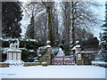
West Hallam War Memorial and gates to St Wilfred's Church
Image: © Tim Rowe
Taken: 10 Nov 2009
0.01 miles
2
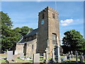
West Hallam, Derbyshire, St Wilfrid of York
Image: © Dave Kelly
Taken: 4 Aug 2018
0.03 miles
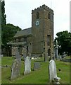
3
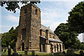
Church of St Wilfrid, West Hallam
View from the south west. The tower is 15th century, Perpendicular, as is the clerestory. The Listing description comments that the 20th century boiler house is “not of special interest”!
Image: © Alan Murray-Rust
Taken: 21 Jul 2017
0.03 miles
4
Church of St Wilfrid, West Hallam
View from the north west. The tower is 15th century, Perpendicular.
Image: © Alan Murray-Rust
Taken: 21 Jul 2017
0.03 miles
5
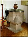
Church of St Wilfrid, West Hallam
The font. The date and origin of this are a mystery. One suggestion is that it is the base of an old village cross, but it does not appear sufficiently weathered for this. It was installed in the church in 1878 after being discovered in Derby and investigations following this suggested that it probably came from West Hallam Hall, home to a Roman Catholic family who would have used it for secret baptisms. It was thought to have been presented to Derby Museum from the ancient chapel at Mapperley, which was replaced by a new building in 1851.
Image: © Alan Murray-Rust
Taken: 21 Jul 2017
0.03 miles
6
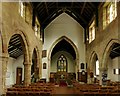
Church of St Wilfrid, West Hallam
The nave, looking east. This view shows the distinct difference in colour in the stone used in the south arcade and the clerestory above it, the latter matching the north side arcade and clerestory. South arcade (right) is early 14th century, chancel arch mid 14th century, clerestory 15th century.
Image: © Alan Murray-Rust
Taken: 21 Jul 2017
0.03 miles
7
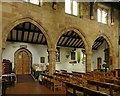
Church of St Wilfrid, West Hallam
The north aisle arcade. Thought by some sources to be late 13th century, although Pevsner considers it “hard to date”. The lack of a break in the stonework between the arcade and the clerestory, in comparison with the south arcade http://www.geograph.org.uk/photo/5477222 suggests it could be contemporary with the addition of the clerestory, mid/late 15th century. Notably the 14th century south arcade and chancel arch are not formed from the same red ironstone.
Image: © Alan Murray-Rust
Taken: 21 Jul 2017
0.03 miles
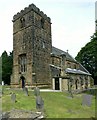
8
St.Wilfred's church
14th & 15th century parish church, restored in the 19th century
Image: © Richard Croft
Taken: 3 Aug 2011
0.03 miles
9
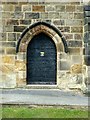
Church of St Wilfrid, West Hallam
The south door. The doorway is 14th century, and the studded door is also clearly of considerable age. This would have been the normal entrance to the church until the north porch, on the side nearest the village, was added in the 19th century.
Image: © Alan Murray-Rust
Taken: 21 Jul 2017
0.04 miles
10
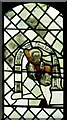
Church of St Wilfrid, West Hallam
Stained glass in the south clerestory. This represents St James the Less carrying the fuller's bat with which he was martyred in 62AD. It is reputed to have come from Dale Abbey, by way of West Hallam Hall, and would therefore be 15th or early 16th century, judging by the style.
Image: © Alan Murray-Rust
Taken: 21 Jul 2017
0.04 miles