IMAGES TAKEN NEAR TO
Field Road, ILKESTON, DE7 5RR
Introduction
This page details the photographs taken nearby to Field Road, DE7 5RR by members of the Geograph project.
The Geograph project started in 2005 with the aim of publishing, organising and preserving representative images for every square kilometre of Great Britain, Ireland and the Isle of Man.

There are currently over 7.5m images from over14,400 individuals and you can help contribute to the project by visiting https://www.geograph.org.uk
Image Map (Loading...)


Getting Data...Please wait
Leaflet Map data © OpenStreetMap
Images are licensed for reuse under creativecommons.org/licenses/by-sa/2.0
Notes
- Clicking on the map will re-center to the selected point.
- The higher the marker number, the further away the image location is from the centre of the postcode.
Image Listing (27 Images Found)
Images are licensed for reuse under creativecommons.org/licenses/by-sa/2.0
Image
Details
Distance
1
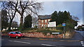
Day Nursery, Stanton Road
At the junction of Black Hills Drive.
Image: © Peter Barr
Taken: 8 Dec 2014
0.11 miles
3
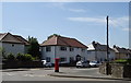
Houses on Hobson Drive, Little Hallam, Ilkeston
Postbox No. DE7 1334.
Image: © JThomas
Taken: 29 Jun 2019
0.13 miles
4

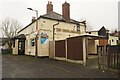
Eden Surgery in Ilkeston
Situated on Cavendish Road to the south of the town centre.
Image: © Jonathan Clitheroe
Taken: 4 Jan 2014
0.14 miles
7
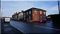
Stanton Road and Havelock Street, Ilkeston
The house in view stands on the site of a former Drill Hall. See Image]
Image: © Peter Barr
Taken: 8 Dec 2014
0.16 miles
8
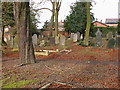
Stanton Road Cemetery, Ilkeston
The cemetery was created in 1863 by a local businessman as a non-denominational cemetery for the growing town. The last burial took place in 1947. It was taken over by the Borough Council in 1968 but gradually fell into disrepair and became overgrown.
After being cleared by the Local History Society in the 1990s, a Friends of Stanton Road Cemetery group was formed in 2000. A lottery grant in 2009 allowed rebuilding of the cemetery wall and a number of graves to be restored, including that of Samuel Taylor http://www.geograph.org.uk/photo/5497510 .
Image: © Alan Murray-Rust
Taken: 11 Aug 2017
0.16 miles
9
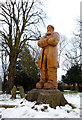
Carving of Samuel Taylor
This large carving created by Andrew Frost can be found in the Stanton Road Graveyard. The carving is a depiction of Samuel Taylor, Ilkeston's Giant, who was born in the Little Hallam area of the town in 1816 and grew to a height of 7 feet 4½ inches. Standing close to the last resting place of Samuel, his great height is shown on his grave by a footstone marked "ST".
Image: © Patrick Baldwin
Taken: 12 Feb 2012
0.17 miles
10
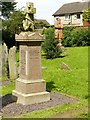
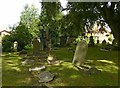
The grave of Samuel Taylor, Stanton Road, Cemetery, Ilkeston
Samuel Taylor was known as the Ilkeston Giant. 7ft 4in tall, he spent his life as a fairground attraction, but expressed a wish to be buried in his home town of Ilkeston. The monument suffered neglect before being restored in the early 20th Century by the Friends of Stanton Road Cemetery. A timber statue of Samuel http://www.geograph.org.uk/photo/5497513 carved from a tree can be seen in the background.
Image: © Alan Murray-Rust
Taken: 11 Aug 2017
0.17 miles