IMAGES TAKEN NEAR TO
West End Crescent, ILKESTON, DE7 5GJ
Introduction
This page details the photographs taken nearby to West End Crescent, DE7 5GJ by members of the Geograph project.
The Geograph project started in 2005 with the aim of publishing, organising and preserving representative images for every square kilometre of Great Britain, Ireland and the Isle of Man.

There are currently over 7.5m images from over14,400 individuals and you can help contribute to the project by visiting https://www.geograph.org.uk
Image Map
Images are licensed for reuse under creativecommons.org/licenses/by-sa/2.0
Notes
- Clicking on the map will re-center to the selected point.
- The higher the marker number, the further away the image location is from the centre of the postcode.
Image Listing (13 Images Found)
Images are licensed for reuse under creativecommons.org/licenses/by-sa/2.0
Image
Details
Distance
1
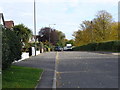
West End Drive, Ilkeston
The white lorries parked on the right-hand side of the road are part of the local fun fair, and have probably come here straight from Nottingham's Goose Fair.
Image: © Oxymoron
Taken: 14 Oct 2008
0.07 miles
2

Ilkeston Enterprise Academy
Built as a local authority secondary school in 1910-14. It was designed by George Widdows, County Architect who developed a progressive philosophy in the design of schools, ensuring plenty of light and cross-ventilation. Although now over 100 years old, it is clearly still 'fit-for-purpose'. This building is Listed Grade II* and a full description is available here https://historicengland.org.uk/listing/the-list/list-entry/1329206 . This side of the building includes the main entrance.
Image: © Alan Murray-Rust
Taken: 28 Jul 2017
0.10 miles
3
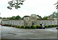
Ilkeston Enterprise Academy
For more information see http://www.geograph.org.uk/photo/5482913 and https://historicengland.org.uk/listing/the-list/list-entry/1329206 . This is the view from the north east showing the quadrangular layout of the building with the domed octagonal hall in the centre https://c20society.org.uk/botm/ilkeston-school-derbyshire/
Image: © Alan Murray-Rust
Taken: 28 Jul 2017
0.13 miles
4
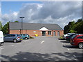
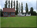
Pewit Golf Course (1)
The score cards say "Pewit Golf Course", but the plaque on the wall of the new brick clubhouse says "Rutland Park Golf Course" - take your choice.
Image: © Oxymoron
Taken: 8 Jul 2008
0.13 miles
5
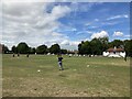
Ilkeston Rutland Cricket Club
East Midlands Women’s Cricket League match on the Rutland Sports Park.
Ilkeston Rutland CC vs Belper Meadows CC
21st August 2022
Image: © Clive Cartwright
Taken: 21 Aug 2022
0.14 miles
6
Pewit Golf Course (3)
Taken from the 4th tee. The white building on the right is the clubhouse of the Ilkeston Borough Golf Club.
Image: © Oxymoron
Taken: 8 Jul 2008
0.18 miles
7
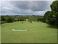
Pewit Golf Course (2)
The view from the 1st tee gives an idea of the undulating nature of this 9 hole municipal golf course.
Image: © Oxymoron
Taken: 8 Jul 2008
0.19 miles
8
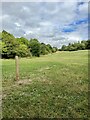
Tee off
One of the tee off post on the golf course.
Image: © Jay Pea
Taken: 23 Aug 2022
0.21 miles
9
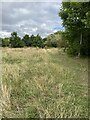
Pathway through the Reserve
Heading in a northeastern direction through the reserve.
Image: © Jay Pea
Taken: 23 Aug 2022
0.22 miles
10
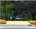
Gateway to Victoria Park, Ilkeston
A fine set of cast iron gates. These were installed as part of the refurbishment of the Park with Heritage Lottery Funding in 2015-6. The originals were presumably lost as war-effort scrap during the Second World War. The park originated in 1897 but was not formally inaugurated until 1902.
Image: © Alan Murray-Rust
Taken: 28 Jul 2017
0.23 miles