
IMAGES TAKEN NEAR TO
Hare Hill Close, ILKESTON, DE7 4SJ
Introduction
This page details the photographs taken nearby to Hare Hill Close, DE7 4SJ by members of the Geograph project.
The Geograph project started in 2005 with the aim of publishing, organising and preserving representative images for every square kilometre of Great Britain, Ireland and the Isle of Man.

There are currently over 7.5m images from over14,400 individuals and you can help contribute to the project by visiting https://www.geograph.org.uk
Image Map
Images are licensed for reuse under creativecommons.org/licenses/by-sa/2.0
Notes
- Clicking on the map will re-center to the selected point.
- The higher the marker number, the further away the image location is from the centre of the postcode.
Image Listing (33 Images Found)
Images are licensed for reuse under creativecommons.org/licenses/by-sa/2.0
Image
Details
Distance
1
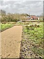
Childrens Playground
As part of the new housing scheme, a playground is being built, unfortunately on a boggy part of the development, and is already underwater.
Image: © Jay Pea
Taken: 11 Jan 2023
0.06 miles
2
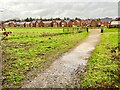
New Housing Development
A lot of new housing has been built on the outskirts of Ilkeston, fortunately these seem to have been built above the floodplain
Image: © Jay Pea
Taken: 11 Jan 2023
0.07 miles
3
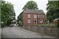
Flamstead House
Looking up Little Hallam Hill. There used to be a railway bridge across the road at this point carrying the Great Northern Railway branch from Ilkeston to the Stanton Ironworks.
Image: © Alan Murray-Rust
Taken: 26 May 2010
0.08 miles
4
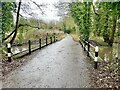
Nutbrook Canal and Bridge
The point on the trail where the disused canal runs under the path.
Image: © Jay Pea
Taken: 11 Jan 2023
0.09 miles
5
Ambivet exotics
One of a chain of veterinary surgeries in the Nottinghamshire / Derbyshire area.
Image: © Peter Barr
Taken: 8 Dec 2014
0.10 miles
6
Little Hallam Hill,Ilkeston
Brick built houser with garden and greenhouse, on the A6096 into Ilkeston.
Image: © Peter Barr
Taken: 8 Dec 2014
0.11 miles
7
Former railway bridge, Ladywood Road
Originally a mineral railway line, the Nutbrook Trail now passes under the bridge. Note that a separate pedestrian bridge has been added because of the narrowness of the carriageway.
Image: © Alan Murray-Rust
Taken: 26 May 2010
0.13 miles
8

Drainage Culvert
Drainage culvert underneath the road bridge, complete with shopping trolley.
Image: © Jay Pea
Taken: 11 Jan 2023
0.13 miles
9
Flooded Field
The field between the trail and canal is becoming flooded from the canal over spill.
Image: © Jay Pea
Taken: 11 Jan 2023
0.13 miles
10
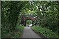
Nutbrook Trail
This is the bridge that carries Little Hallam Hill over the former railway line, now converted to the Nutbrook Trail. This forms part of Sustrans route 67.
Image: © Alan Murray-Rust
Taken: 26 May 2010
0.13 miles