IMAGES TAKEN NEAR TO
Elka Road, ILKESTON, DE7 4SE
Introduction
This page details the photographs taken nearby to Elka Road, DE7 4SE by members of the Geograph project.
The Geograph project started in 2005 with the aim of publishing, organising and preserving representative images for every square kilometre of Great Britain, Ireland and the Isle of Man.

There are currently over 7.5m images from over14,400 individuals and you can help contribute to the project by visiting https://www.geograph.org.uk
Image Map
Images are licensed for reuse under creativecommons.org/licenses/by-sa/2.0
Notes
- Clicking on the map will re-center to the selected point.
- The higher the marker number, the further away the image location is from the centre of the postcode.
Image Listing (3 Images Found)
Images are licensed for reuse under creativecommons.org/licenses/by-sa/2.0
Image
Details
Distance
1
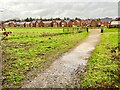
New Housing Development
A lot of new housing has been built on the outskirts of Ilkeston, fortunately these seem to have been built above the floodplain
Image: © Jay Pea
Taken: 11 Jan 2023
0.19 miles
2
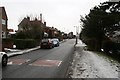
Longfield Lane
Heading toward the Hallam Fields area of Ilkeston.
Image: © David Lally
Taken: 12 Jan 2010
0.23 miles
3
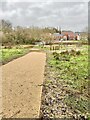
Childrens Playground
As part of the new housing scheme, a playground is being built, unfortunately on a boggy part of the development, and is already underwater.
Image: © Jay Pea
Taken: 11 Jan 2023
0.23 miles