IMAGES TAKEN NEAR TO
Roberts Close, DERBY, DE74 2HR
Introduction
This page details the photographs taken nearby to Roberts Close, DE74 2HR by members of the Geograph project.
The Geograph project started in 2005 with the aim of publishing, organising and preserving representative images for every square kilometre of Great Britain, Ireland and the Isle of Man.

There are currently over 7.5m images from over14,400 individuals and you can help contribute to the project by visiting https://www.geograph.org.uk
Image Map
Images are licensed for reuse under creativecommons.org/licenses/by-sa/2.0
Notes
- Clicking on the map will re-center to the selected point.
- The higher the marker number, the further away the image location is from the centre of the postcode.
Image Listing (71 Images Found)
Images are licensed for reuse under creativecommons.org/licenses/by-sa/2.0
Image
Details
Distance
1
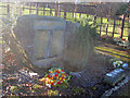
Kegworth Air Disaster Memorial
The air disaster occurred on the 8th of January 1989. British Midland Flight 92, a Boeing 737-400, crashed onto the embankment of the M1 motorway nearby when attempting an emergency landing at East Midlands Airport. Of the 126 people on board, 47 died and 74 sustained serious injuries. This memorial to 'those who died, those who were injured and those who took part in the rescue operation' lists the names of the 47 people who died and is surrounded by a small garden made of soil from the crash site.
http://www.kegworthvillage.com/show_page.php?id=2
http://en.wikipedia.org/wiki/Kegworth_air_disaster
Image: © Trevor Rickard
Taken: 8 Jan 2011
0.05 miles
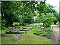
2
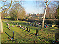
Kegworth Cemetery
View north across the village to Ratcliffe Power Station in the distance.
Image: © Trevor Rickard
Taken: 8 Jan 2011
0.07 miles
3
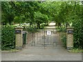
Kegworth Cemetery
The entrance on Ashby Road.
Image: © Alan Murray-Rust
Taken: 13 Jun 2018
0.08 miles
4
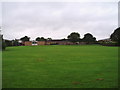
Playing fields, Kegworth Primary School
Image: © Eirian Evans
Taken: 5 Aug 2008
0.11 miles
6
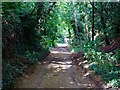
New Brickyard Lane
Despite the name, the brickyard is long gone.
Image: © Ian Calderwood
Taken: 3 Aug 2016
0.13 miles
7
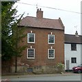
40 London Road, Kegworth (Friends Cottage)
The name derives from its former use as a Quaker (Society of Friends) meeting house. Mid 18th century, Listed Grade II.
Image: © Alan Murray-Rust
Taken: 13 Jun 2018
0.14 miles
8
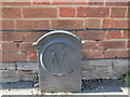
Stone outside Lodge Farmhouse
LCWW - Leicestershire County Water Works? Any ideas?
Image: © Jonathan Thacker
Taken: 25 Apr 2023
0.15 miles
9
Lodge Farmhouse, Kegworth
Late eighteenth century house https://historicengland.org.uk/listing/the-list/list-entry/1084359?section=official-list-entry
Image: © Jonathan Thacker
Taken: 25 Apr 2023
0.15 miles
10
Britannia House
The Britannia Inn closed at the end of 2011 and has since been converted, to quote the planning application, "... to form two residential units in multiple occupation along with the erection of a new building in the car park to form two residential units in multiple occupation".
Image: © Ian Calderwood
Taken: 1 Sep 2015
0.16 miles