IMAGES TAKEN NEAR TO
Spinney Hill, DERBY, DE73 8LX
Introduction
This page details the photographs taken nearby to Spinney Hill, DE73 8LX by members of the Geograph project.
The Geograph project started in 2005 with the aim of publishing, organising and preserving representative images for every square kilometre of Great Britain, Ireland and the Isle of Man.

There are currently over 7.5m images from over14,400 individuals and you can help contribute to the project by visiting https://www.geograph.org.uk
Image Map
Images are licensed for reuse under creativecommons.org/licenses/by-sa/2.0
Notes
- Clicking on the map will re-center to the selected point.
- The higher the marker number, the further away the image location is from the centre of the postcode.
Image Listing (7 Images Found)
Images are licensed for reuse under creativecommons.org/licenses/by-sa/2.0
Image
Details
Distance
1

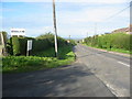
A track to nowhere
Just a small barn at the end of this track, not a farm house as one would perhaps expect. This is a right of way, but that branches off to the right across the field after 100 metres or so.
Image: © David Lally
Taken: 21 Jun 2023
0.10 miles
2
Fergiland
Fergiland - nothing to do with royalty or football managers, but a useful place to obtain Ferguson tractor parts.
Image: © Mike Bardill
Taken: 30 Sep 2006
0.17 miles
4
Junction of Cockshut Lane and Derby Road
Cockshut Lane forms the official route of the B587 towards Ashby, avoiding the centre of Melbourne.
Image: © Jerry Evans
Taken: 30 Jan 2008
0.22 miles
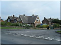
5
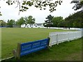
Melbourne Town Cricket Club
The club's ground in Melbourne Sports Park on Cockshut Lane
Image: © Graham Hogg
Taken: 9 May 2017
0.23 miles
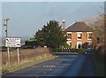
6
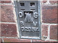
Ordnance Survey Flush Bracket G2354
This bracket can be found on the wall of a house in Derby Road.
For more detail see : http://www.bench-marks.org.uk/bm13164
Image: © Peter Wood
Taken: 2 Sep 2012
0.23 miles