IMAGES TAKEN NEAR TO
Earp Way, DERBY, DE73 8JQ
Introduction
This page details the photographs taken nearby to Earp Way, DE73 8JQ by members of the Geograph project.
The Geograph project started in 2005 with the aim of publishing, organising and preserving representative images for every square kilometre of Great Britain, Ireland and the Isle of Man.

There are currently over 7.5m images from over14,400 individuals and you can help contribute to the project by visiting https://www.geograph.org.uk
Image Map
Images are licensed for reuse under creativecommons.org/licenses/by-sa/2.0
Notes
- Clicking on the map will re-center to the selected point.
- The higher the marker number, the further away the image location is from the centre of the postcode.
Image Listing (6 Images Found)
Images are licensed for reuse under creativecommons.org/licenses/by-sa/2.0
Image
Details
Distance
1
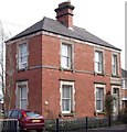
Turnbarrel House
The carving above the door still says "CONSTABULARY".
Image: © Ian Calderwood
Taken: 10 Apr 2010
0.13 miles
2
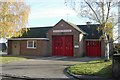
Melbourne fire station
Melbourne fire station, Castle Street, Melbourne, Derbyshire
Image: © Kevin Hale
Taken: 19 Nov 2006
0.22 miles
3
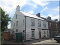
Building work beside Station Road, Melbourne
I think this used to be the Railway Hotel and, at one time according to Old Maps, The Clifton Arms Inn.
Image: © John Slater
Taken: 6 Jul 2014
0.23 miles
5
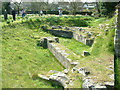
The remains of Melbourne Castle Derbyshire
These few stones are all that remains of Melbourne Castle. Much of the castle stone was robbed for re-use in other buildings in Melbourne. The foundations you can see are NOT normally open to the public. We had special access during Melbourne weekend, which is an arts based two days where some people open their homes and display art work by local and other people.
Image: © Malcolm Neal
Taken: 12 Apr 2003
0.24 miles