IMAGES TAKEN NEAR TO
Shepherds Lane, DERBY, DE73 8HT
Introduction
This page details the photographs taken nearby to Shepherds Lane, DE73 8HT by members of the Geograph project.
The Geograph project started in 2005 with the aim of publishing, organising and preserving representative images for every square kilometre of Great Britain, Ireland and the Isle of Man.

There are currently over 7.5m images from over14,400 individuals and you can help contribute to the project by visiting https://www.geograph.org.uk
Image Map
Images are licensed for reuse under creativecommons.org/licenses/by-sa/2.0
Notes
- Clicking on the map will re-center to the selected point.
- The higher the marker number, the further away the image location is from the centre of the postcode.
Image Listing (5 Images Found)
Images are licensed for reuse under creativecommons.org/licenses/by-sa/2.0
Image
Details
Distance
2
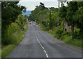
Road and reservoir, Derby Hills
Taken while looking for Ordnance Survey "furniture" buried in the verge.
Image: © Richard Webb
Taken: 6 Jan 2004
0.13 miles
3
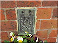
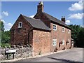
Ordnance Survey Flush Bracket 302
This can be found on the wall of The Cottages.
For more detail see : http://www.bench-marks.org.uk/bm985
Image: © Peter Wood
Taken: 2 Sep 2012
0.17 miles